


|
||

|

|
|

|
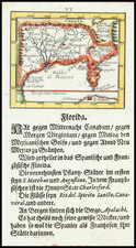
First State, First Printing.
Virginiae Item et Floridae Americae Provinciarum, nova Descriptio, produced by Johannes Cloppenburg and published in Amsterdam in 1630, is a detailed representation of the Carolinas along with parts of Virginia and Georgia. Covering an expanse from St. Augustine to the north of "Chesepioock Sinus" and extending westward to the Alleghany Mountains, this map provides a precise account of the region, marking several emerging towns of the period.
The 17th century was a time of increasing European exploration and colonization in the Americas. Cartography played a pivotal role in these endeavors, providing essential knowledge for navigation and territorial claims. This map by Cloppenburg finds its origins in Jodocus Hondius's 1606 map of the region. The plate, though unsigned, is probably the work of Pieter van den Keere.
A highly collectible early map of the Southeast.
States
- 1630. No plate number engraved in the top right hand corner.
- 1673. The shot silk or moiré effect in the sea is removed.
- c. 1738. The plate number 254 engraved top right.
Johannes Cloppenburg (sometimes Cloppenburgh; also H. Jan Evertsz and Johannes Everhardus) was a Dutch cartographer. Based in Amsterdam, he was active between roughly 1610 and 1644. He worked closely with the Hondius/Jansson firm and is credited with the 1630 edition of the Atlas Minor.
![[French Colonization in Florida and the Southeast] La Floride Francoise Dressee sur La Relation des Voiages que Ribaut, Laudonier, et Gourgues y ont faits in 1562, 1564 et 1567 . . .](https://storage.googleapis.com/raremaps/img/small/91072.jpg)

![[ North Carolina ] Neueste Karte von Nord Carolina mit seinen Canaelen, Strassen, Eisenbahnen, Entfernung . . . .1845](https://storage.googleapis.com/raremaps/img/small/89079.jpg)
![Map of the States of North & South Carolina [Large Charleston Inset]](https://storage.googleapis.com/raremaps/img/small/91846.jpg)
![[British Colonies in America] Carte Qui Contient Une Description Des Iles & Terres Que Les Anglois . . .[maps of Chesapeake, Carolinas, New England, Bermuda, Gulf Coast, Jamaica, Barbadoes & Canada]](https://storage.googleapis.com/raremaps/img/small/61480.jpg)