|
||

|

|
|

|
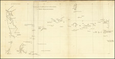
Nice example of the Mercator-Hondius Atlas Minor map of Southeast Asia, the Philippines and India.
The "India Orientalis" map, published circa 1610 for the Mercator-Hondius Atlas Minor, is a captivating testament to the early modern understanding of Southeast Asia, the Philippines, and India, and a aluable snapshot of the region during the era of growing European exploration and trade.
The map spans an impressive geographical extent, from India's western edges and the Maldives to the coasts of southern China and the Philippine Islands, encapsulating a significant portion of the Asian continent. It offers a particular focus on the important trading regions of the "East Indies", demonstrating the state of knowledge that Europe held about this distant and diverse part of the world.
The map depicts the entirety of the Malay Peninsula, the emerging hub of Southeast Asia. Major port cities, like Malacca, a critical stopover on the spice route, are clearly marked. The representation of the peninsula hints at the region's growing importance as a nexus of trade and cultural exchange.
Adjacent to the Malay Peninsula, the map encompasses all of Indochina, representing the present-day countries of Vietnam, Laos, and Cambodia. This area, rich in both natural resources and cultural heritage, was largely unknown to Europeans at the time, and its appearance on the map demonstrates the explorers' and mapmakers' eagerness to record and comprehend these distant lands.
Further south, the map extends to include the northern part of Borneo. While not yet fully explored or understood by Europeans during this period, the inclusion of Borneo indicates the island's significance in regional trade networks and early navigation charts.
The Philippines, an archipelago that was of considerable interest to Europe due to its strategic location and rich resources. The island group's depiction provides a fascinating look at the region before the height of colonial influence.
In its totality, the map serves as a window into a world gradually becoming more connected. Its geographical details reveal the complexities of the regions it represents, while its existence as a product of the Mercator-Hondius Atlas Minor testifies to the growing European interest in these regions.
Gerard Mercator is one of the most famous cartographers of all time. Mercator was born in Flanders and educated at the Catholic University in Leuven. After his graduation in 1532, Mercator worked with Gemma Frisius, a prominent mathematician, and Gaspar a Myrica, a goldsmith and engraver. Together, these men produced globes and scientific instruments, allowing Mercator to hone his skills.
With his wife, Barbara, Mercator had six children: Arnold, Emerentia, Dorothes, Bartholomeus, Rumold, and Catharina. In 1552, Mercator moved to Duisburg from Leuven, where he lived for the rest of his life. In 1564, he was appointed the official cosmographer to the court of Duke Wilhelm of Cleve.
Mercator’s most important contribution was the creation and popularization of a projection which now bears his name. On Mercator projection maps, all parallels and meridians are drawn at right angles to each other, with the distance between the parallels extending towards the poles. This allowed for accurate latitude and longitude calculation and also allowed navigational routes to be drawn using straight lines, a huge advantage for sailors as this allowed them to plot courses without constant recourse to adjusting compass readings.
Mercator’s other enduring contribution to cartography is the term “atlas”, which was first used to describe his collection of maps gathered in one volume. The Mercator atlas was published in 1595, a year after Mercator’s death, thanks to the work of his sons, particularly Rumold, and his grandsons.

![[ Pakistan & India ]](https://storage.googleapis.com/raremaps/img/small/103982.jpg)
![[ China Sea / Luzon / Hong Kong / Canton / Formosa ] Bogt Toncqin (VOC - Dutch East India Chart by Its Chief Map Maker in Batavia)](https://storage.googleapis.com/raremaps/img/small/64690.jpg)
![[ Bombay ] Plan du Port de Bombay situe par 19 deg. de Lattit. Nord et par 70 deg. 41 min de Longit du Meridien de Paris](https://storage.googleapis.com/raremaps/img/small/95158.jpg)
![[ Dalai Lama ] Grand Lama](https://storage.googleapis.com/raremaps/img/small/97873.jpg)