|
||

|

|
|

|
Unrecorded Spanish World Map
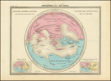
Planisferio Terrestre Indicando Los Nuevos Descubrimientos, Las Colonias Europeas, a grand world map crafted by geographer Alexandre Vuillemin and published by Garnier Frères in Paris in 1850, offers an elaborate cartographic overview of the globe. Notably, it accentuates the new discoveries and the web of European colonies dispersed worldwide, further punctuated by the major maritime routes traversed by steamships between principal trading ports.
This map, drawn by Vuillemin and corrected by F. Corona Bustamante, presents the world with exquisite detail and remarkable precision. Its inclusion of an extensive Antarctic coastline exemplifies the scientific advancements and geographic discoveries of the era. Furthermore, the map utilizes distinct symbols to indicate different European colonies, providing a clear visual representation of the colonial powers at the time.
Supplementing the geographical detail, the map incorporates numerous vignette scenes of major ports, along with arctic and antarctic views, scattered across the canvas. These decorative elements serve not only as aesthetic enhancements but also as cultural narratives, encapsulating the diversity of human experiences and interactions across the globe.
The Planisferio Terrestre Indicando Los Nuevos Descubrimientos, Las Colonias Europeas stands as a significant piece of mid-19th century cartography. It weaves together global geography, colonial territories, maritime commerce, and cultural vignettes, thus providing a panoramic view of a world in the throes of exploration, colonization, and burgeoning global trade.
Rarity
We were unable to find another example of the map in any bibliographic sources.
![[Medieval World Map] Das ist die mapa mudi und alle Land un Kungkreich wie sie ligend in der ganze Welt](https://storage.googleapis.com/raremaps/img/small/102356.jpg)
![Western Hemisphere [and:] Eastern Hemisphere](https://storage.googleapis.com/raremaps/img/small/102187.jpg)