|
||

|

|
|

|
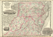
Issued in 1827 by Jean Baptiste Bory de Saint-Vincent, the Carte Des Montagnes Coupees par Des Rivieres, Situees en Virginie et en Pensylvanie provides an accurate and detailed geographical representation of Virginia and Pennsylvania's river-intersected mountainous terrains.
Historically, this map provides valuable insight into the early 19th-century landscape of the depicted regions. The course of rivers and the spread of mountains presented here allow for a deeper understanding of how these physical features might have influenced the economic and social development of Virginia and Pennsylvania during this period.
This map was part of the esteemed publication, the Atlas encyclopédique contenant les cartes et les planches relatives à la géographie physique.
![(Kentucky Borderlands) [An original manuscript account detailing a trip to and from Kentucky via the Ohio River, including the return trip via the Old Wilderness Trail, with two hand-drawn plat maps] An Account of Expences in Travelling to and from Kentucky in search of Land Claimed by Mr. H. McClery & Myself.](https://storage.googleapis.com/raremaps/img/small/81445.jpg)
![[ First Postal Map of Pennsylvania & New Jersey ] Map of New Jersey and Pennsylvania Exhibiting the Post Offices, Post Roads, Canals, Rail Roads, & c.](https://storage.googleapis.com/raremaps/img/small/103212.jpg)
![[Revolutionary War Plans of New York, Boston, Charleston, Delaware River to Philadelphia & Havana] Various Plans and Draughts of Cities, Towns, Harbours &c . . .](https://storage.googleapis.com/raremaps/img/small/83450.jpg)
![[ Baltimore ] Map of the City and Suburbs of Baltimore Compiled from Actual Surveys 1853 . . .](https://storage.googleapis.com/raremaps/img/small/102136.jpg)