|
||

|

|
|

|
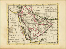
Fascinating map of the Arabian Peninsula in ancient times, published by the British cartographer Aaron Arrowsmith.
This map, written in Latin and devoid of any modern names, focuses on an expansive region — the ancient Arabian Peninsula and its surrounding water bodies, notably the Mediterranean Sea (Mare Medio), the Arabian Gulf (Arabicum Sinum), the Red Sea (Mare Erythraeum), the Persian Gulf (Persicum Sinum), and the Euphrates River (Euphratem fl.).
The Mediterranean Sea, which translates to the 'Middle Sea', has been an essential trade and travel route since ancient times. It saw the rise of several civilizations including the Egyptians, Greeks, and Romans, each leaving their mark on history through art, philosophy, and architectural marvels. With intricate details on the map, Arrowsmith perfectly captures the essence of this cradle of civilizations.
Moving southeastward, we encounter the Arabian Gulf or Arabicum Sinum. This water body has been home to several ancient cultures, including the Dilmun civilization, regarded by some as the original Garden of Eden. The map reflects the various islands and coastal cities that dotted this region, serving as major trade hubs between Mesopotamia, the Indian subcontinent, and East Africa.
Further south, the Red Sea or Mare Erythraeum is represented, a crucial trade route that connected the Roman Empire with the Kingdom of Aksum and India. Arrowsmith's map details the ancient ports along its coast, such as the Egyptian Berenike, showcasing its importance in fostering cultural exchange and economic prosperity.
To the east of the Arabian Peninsula lies the Persian Gulf or Persicum Sinum, an area of immense historical significance. Ancient civilizations like the Sumerians, Babylonians, and Persians thrived here, cultivating arts, sciences, and literature. The map subtly illustrates the Tigris and Euphrates rivers' convergence, marking the location of the ancient Mesopotamian city of Ur, which saw the birth of writing and law.
Finally, the Euphrates River or Euphratem fl., the longest river of Western Asia, is also depicted on the map. The river played a key role in the establishment of the Mesopotamian civilization, particularly in areas like irrigation and transportation. Arrowsmith highlights its winding course, offering viewers an understanding of the river's significance in shaping human history.
The Arrowsmiths were a cartographic dynasty which operated from the late-eighteenth century to the mid-nineteenth. The family business was founded by Aaron Arrowsmith (1750-1823), who was renowned for carefully prepared and meticulously updated maps, globes, and charts. He created many maps that covered multiple sheets and which were massive in total size. His spare yet exacting style was recognized around the world and mapmakers from other countries, especially the young country of the United States, sought his maps and charts as exemplars for their own work.
Aaron Arrowsmith was born in County Durham in 1750. He came to London for work around 1770, where he found employment as a surveyor for the city’s mapmakers. By 1790, he had set up his own shop which specialized in general charts. Arrowsmith had five premises in his career, most of which were located on or near Soho Square, a neighborhood the led him to rub shoulders with the likes of Joseph Banks, the naturalist, and Matthew Flinders, the hydrographer.
Through his business ties and employment at the Hydrographic Office, Arrowsmith made other important relationships with Alexander Dalrymple, the Hudson’s Bay Company, and others entities. In 1810 he became Hydrographer to the Prince of Wales and, in 1820, Hydrographer to the King.
Aaron Arrowsmith died in 1823, whereby the business and title of Hydrographer to the King passed to his sons, Aaron and Samuel, and, later, his nephew, John. Aaron Jr. (1802-1854) was a founder member of the Royal Geographical Society (RGS) and left the family business in 1832; instead, he enrolled at Oxford to study to become a minister. Samuel (1805-1839) joined Aaron as a partner in the business and they traded together until Aaron left for the ministry. Samuel died at age 34 in 1839; his brother presided over his funeral. The remaining stock and copper plates were bought at auction by John Arrowsmith, their cousin.
John (1790-1873) operated his own independent business after his uncle, Aaron Arrowsmith Sr., died. After 1839, John moved into the Soho premises of his uncle and cousins. John enjoyed considerable recognition in the geography and exploration community. Like Aaron Jr., John was a founder member of the RGS and would serve as its unofficial cartographer for 43 years. Several geographical features in Australia and Canada are named after him. He carried the title Hydrographer to Queen Victoria. He died in 1873 and the majority of his stock was eventually bought by Edward Stanford, who co-founded Stanford’s map shop, which is still open in Covent Garden, London today.
![Arabiae Veteris Typus [Map of Ancient Arabia]](https://storage.googleapis.com/raremaps/img/small/93085.jpg)
![[Arabia] Tabula Asiae VI](https://storage.googleapis.com/raremaps/img/small/87151.jpg)