


|
||

|

|
|

|
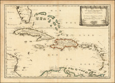
Les Antilles, created by Martineau Du Plessis and published in Amsterdam in 1700, offers a compelling portrayal of the Greater and Lesser Antilles. The map showcases an excellent representation of these Caribbean islands, drawing heavily on the influential work of the geographer Johannes De Laet.
De Laet, a director of the Dutch West India Company, was known for his accurate and comprehensive cartographic work on the Americas. Du Plessis' map echoes his style, detailing the intricacies of the Caribbean island groups with remarkable precision for the time.
The map, beautifully crafted and visually compelling, serves as a window into the Antilles at the turn of the 18th century, capturing both the geography of the islands and the cartographic knowledge and skill of its creator.
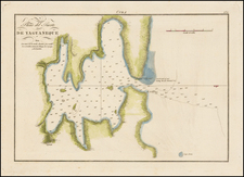
![[ Charleston, Boston, New York, St. Augustine, Bahamas, etc ] Particular Draughts of some of the Principal Towns and Harbours belonging to the English French and Spanish in America and the West Indies.](https://storage.googleapis.com/raremaps/img/small/102804.jpg)
![[Hand Drawn Map] Le Golfe de Mexique avec les Pays Circonvoisins](https://storage.googleapis.com/raremaps/img/small/91580.jpg)
![Map of Mexico, Central America, and the West Indies [Insets of Bermuda, Sandwich Islands, Jamaica and Panama Railroad]](https://storage.googleapis.com/raremaps/img/small/78369.jpg)
![The West India Islands, and Central America [with] Jamaica](https://storage.googleapis.com/raremaps/img/small/78675.jpg)