|
||

|

|
|

|
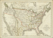
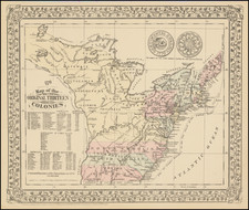
Expanding Territories in the Upper Midwest On the Eve of the the Toledo War
Scarce H.S. Tanner map of the United States from 1835, representing an era of evolution and westward expansion, defined by raw ambition and political maneuvering.
This map extends west to the Mississippi River, the lifeblood of the nation during this period, supporting burgeoning commerce and transportation. To the south, Louisiana—admitted to the Union in 1812, along with Arkansas Territory (statehood received in 1836) and Missouri (statehood received in 1821) respectively, offer a balance in the south-central region of the country.
Further north, a blank expanse west of Michigan would soon see the formation of Iowa Territory and Wisconsin Territory. The Iowa Territory, created on July 4, 1838, from the Wisconsin Territory, was composed of present-day Iowa, Minnesota, and parts of North and South Dakota. Later, Iowa would become the 29th state of the Union in 1846, while Minnesota, after a sequence of territorial modifications, would attain statehood in 1858.
The Wisconsin Territory, established in 1836, originally included lands that make up present-day Wisconsin, Minnesota, Iowa, and parts of North and South Dakota. Wisconsin would be admitted as the 30th state in the Union in 1848, leaving behind the territories that would eventually form Minnesota and Iowa.
To the east, the Michigan Territory, established in 1805, included not only the lower and upper peninsulas of present-day Michigan but also a portion of present-day Wisconsin. Michigan, after resolving the contentious "Toledo War" border dispute with Ohio, was admitted to the Union as the 26th state in 1837.