|
||

|

|
|

|
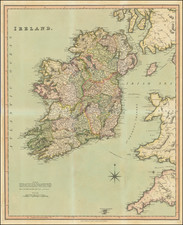
"In Ireland, the map possesses the same pioneer status as is held in England and Wales by William Smith's map..." - Gordon L. Davies
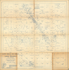
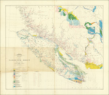
A Beautiful Copy of the Monumental Wall Map, Hand-Colored by Counties.
A handsome example of Richard Griffith's masterwork, the first large-scale geological map of Ireland, published in Dublin in 1839.
This enormous six-sheet map was produced for the National Railway Commission and shows the magnificent base topography of Ireland at the impressive quarter-inch-to-the-mile scale. The map represents the culmination of a quarter-century of labor by Richard Griffith, a key figure in mid-19th century Ireland, who it was said was involved in every major public works project of the time.
This example is from the 1855 edition of the map, which has been re-engraved to refine the geological information presented. The map includes additional cross-sections as well as a list of the principal fossils to be found in the region. The proof copy of this edition was ready in 1855, but copies of that edition colored with geological information were ready only from 1856.
The detail on the map is extraordinary, with topography, towns, loughs, roads, and much more shown throughout the country at a resolution of several hundred yards. Mines are marked on the map, including gold, iron, copper, lead, coal, and antimony diggings. Off the west coast of the country are additional key boxes that could be hand-colored.
Griffith and the Early Geological Mapping of Ireland
The Griffith map has been the subject of extensive research. Griffith first had a manuscript geological map of the entire island sometime around 1815, when he first referred to a manuscript map in one of his lectures. It is known that made many editions of this manuscript map, slowly coloring in portions of the country as he and other geologists mapped ever-increasing portions of the island. However, it was thought that all examples of Griffith's manuscript maps were lost until the recent discovery of an annotated Alexander Taylor map appeared in the archives of the Geological Society.
A printed map by Griffith would have to wait until 1838 when he published the first geological map of Ireland at a scale reduced from the present (1 inch to 10 miles). This map accompanied a railroad report which he was also involved in. In 1839, the enlarged and significantly more detailed version of his map appeared, which remained in circulation throughout the 19th century as the foremost authority on the geology of the country.
Griffith retained the 1839 dating on the map until 1855 despite continuously updating the map with the work of other researchers. This practice drew criticism at the time as some felt that this practice suggested that he, in fact, discovered the newly-depicted elements first. Perhaps to assuage this criticism, a member of the Irish Ordnance Survey (usually James Duncan) would date the map in the lower right of each sheet. In addition, Griffith would sometimes change the date on the map himself when presenting to a scientific audience likely to know that the work on the map was not exclusively his own.
Rarity
The map is scarce. Only nine examples are listed in OCLC.