


|
||

|

|
|

|
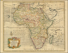
Fascinating map of the southern part of of Africa, originally compiled by George Cawston, capturing a critical time in African history, namely the division and colonization of the continent by European powers.
The British South Africa Company is prominently marked in red on the map, accompanied by extensive notes identifying conventions, administrative declarations, lines of demarcation, Free Trade Areas for the Maritime Zone and Arid Basin of the Congo, customs leased to Germany, Memorandums, and other instruments employed to carve up the region between 1884 and 1891.
The Berlin Conference of 1885 played a crucial role in these delineations. It set the stage for the "Scramble for Africa," during which most of the continent fell under colonial rule. Ethiopia and Liberia were the only two nations to retain independence during this period.
Subsequent to the Berlin Conference, various treaties and agreements were signed to further define territorial boundaries and spheres of influence. Notable among them are agreements between Britain and France, whereby France acknowledged British control over Zanzibar and Nigeria, and Britain recognized French domination over Madagascar. Similar treaties were also forged between Britain and Germany, recognizing German East Africa and Uganda under German and British influence, respectively.
The 1890 British Ultimatum and subsequent Treaty of London in August of that year further defined the borders of Portuguese colonies, Mozambique and Angola, as Britain pressed Portugal to withdraw its forces from the land connecting these territories.
The British South Africa Company, highlighted in red on the map, was formed in 1889 following the amalgamation of Cecil Rhodes' Central Search Association and the London-based Exploring Company Ltd. With backing from influential figures like Baron Nathan de Rothschild, Lord Gifford, and George Cawston, and the receipt of a Royal Charter modeled on that of the British East India Company, the British South Africa Company aimed to promote colonization and economic exploitation across much of south-central Africa.
Cecil Rhodes' ambitious vision was to create a zone of British influence from "Cape to Cairo," but the lack of expected gold wealth in Mashonaland and other factors, including the acquisition of Katanga by the Congo Free State, limited the company's ability to realize this dream.
The map stands as a vivid representation of a complex and tumultuous period in African history. It shows not only the physical geography of the region but also the political maneuvering, negotiations, and ambitions that shaped the continent's destiny. The myriad of notes, agreements, and treaties referenced on the map reveal the intricate web of diplomacy and power struggles that characterized the late 19th-century division of Africa. It serves as a visual record of an era that laid the groundwork for present-day national boundaries and political configurations, and reflects the challenges and legacies of colonial rule.
Edward Stanford (1827-1904) was a prominent British mapmaker and publisher. A native of Holborn in the heart of London, Edward was apprenticed to a printer and stationer at the age of 14. After his first master died, he worked with several others, including Trelawny W. Saunders of Charing Cross. Saunders oversaw young Edward’s early career, ensuring that he became a Fellow of the Royal Geographical Society. Associations with the Society eventually brought Sanders much business and gave him a reputation as a publisher of explorers. As testament to this reputation, the Stanford Range in British Columbia was named for him by John Palliser.
Stanford briefly partnered with Saunders in 1852 before striking out on his own in 1853. He was an agent for the Ordnance Survey, the Admiralty, the Geological Survey, the Trigonometrical Survey of India, and the India Office. He also controlled the maps of the Society for the Diffusion of Useful Knowledge, another lucrative source of income. In 1857, Stanford founded his namesake Geographical Establishment, with Saunders and A. K. Johnston as engravers. Thereafter, Stanford was known for his “library maps”, particularly those of Africa and Asia.
Addresses and Years of Operation:
- 6 Charing Cross, London (1848): Edward Stanford's initial place of employment at Trelawney Saunders' shop.
- 7 and 8 Charing Cross, London (1853): Stanford expanded his shop to these addresses.
- 55 Charing Cross, London (1873): The shop moved to this larger location.
- 12-14 Long Acre, London (1873): Site of the new print works and current flagship store.
- 7 Mercer Walk, London (2019): Stanfords moved to this address, continuing its legacy.
Stanford's work with Chief Cartographer John Bolton, including the 1858 Library Map of Europe, positioned the company as a leader in quality cartography during a time of exploration and colonialism. Their 1862 Library Map of London earned acclaim from the Royal Geographical Society. With the business thriving, Stanford purchased Staunton & Son in 1877 and, upon retiring in 1885, handed over the reins to his son, Edward Stanford II.
As sole agents for Ordnance Survey Maps, the company's influence and reputation grew, culminating in the Stanford’s London Atlas Of Universal Geography, which was presented to Queen Victoria in 1887. The transition into the 20th century saw further integration of retail, print, and cartographic operations at Long Acre.
During World War I, Stanford's became an essential publisher for the War Office. Edward Fraser Stanford took over in 1917, steering the company through the interwar period and innovations, such as the world’s smallest maps in 1922 and the Daily Mail Motor Road Map in 1926.
Withstanding a bombing in WWII, the company continued under the stewardship of John Keith Stanford and was sold to George Philip & Son in 1947. As it adapted to the digital age, Stanfords received the Ordnance Survey Premier Partner status in 2007 and ventured into online mapping and data services.
Stanfords, now an icon for travellers and explorers, has maintained its cultural relevance and retail success well into the 21st century, underpinned by a legacy of entrepreneurial spirit and commitment to cartographic excellence.
![[Southern Africa] Kaart van het Zuidelykste Gedeelte van Afrika of het Land der Hottentotten](https://storage.googleapis.com/raremaps/img/small/89739.jpg)
![[ French Sudan ] Colonie du Soudan Francais - Carte Routiere dressee au Service Geographique de l'A.O.F. a Dakar, d'apres les renseignements fournis par le Gouvernement du Soudan, ainsi que les leves et itineraires des Offers. et Sous-Offers. du Service Geographique . . . 1927](https://storage.googleapis.com/raremaps/img/small/100560.jpg)