|
||

|

|
|

|
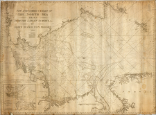
A New Map of Denmark and Sweden is an exquisite work by renowned British cartographer Herman Moll, produced in London about 1726. The map portrays a highly detailed representation of Scandinavia, focusing predominantly on Denmark and Sweden, with an extensive inset map that covers the North part of Norway, Lapland, and Greenland.
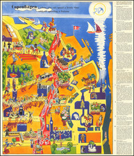
One of the standout features of the map is its series of five engraved vignette scenes along the right edge. These provide a rich, detailed sketch of the lives of the Laplanders, the indigenous Sami people of the Lapland region, with notes explaining each scene. The scenes cover a variety of cultural aspects, from their religious practices and wedding customs, to their burial rites and methods of child rearing. Even their housing structures, both for human residents and for food storage, are depicted.
A unique feature of the map is a scene depicting the indigenous practice of 'praying to Death,' which is the local custom of asking for a longer life. Another scene shows how young children are raised and how they are taught to suckle reindeer. The vignettes provide a vivid depiction of the unique ways in which the Laplanders adapted to their harsh environment, from their ingenious house constructions to protect against wild beasts to the adornment of their clothing.
In the upper-left corner, there's an inset detailing the northern parts of Norway, Lapland, and Greenland (i.e., Spitsbergen). It provides navigation information, including an advisory note on the varying degrees of accuracy in the Longitudes of the North Cape and Archangel due to the lack of celestial observations.
The map is dedicated to the Lord Bishop of Bristol, Lord Privy Seal, and Her Majesty's First Plenipotentiary at the Treaty of Utrecht, reflecting the influence and reach of the British Empire during Moll's time.
State
State 4 (of 6) with John Bowles' imprint substituted for that of Daniel Midwinter Jr.
Herman Moll (c. 1654-1732) was one of the most important London mapmakers in the first half of the eighteenth century. Moll was probably born in Bremen, Germany, around 1654. He moved to London to escape the Scanian Wars. His earliest work was as an engraver for Moses Pitt on the production of the English Atlas, a failed work which landed Pitt in debtor's prison. Moll also engraved for Sir Jonas Moore, Grenville Collins, John Adair, and the Seller & Price firm. He published his first original maps in the early 1680s and had set up his own shop by the 1690s.
Moll's work quickly helped him become a member of a group which congregated at Jonathan's Coffee House at Number 20 Exchange Alley, Cornhill, where speculators met to trade stock. Moll's circle included the scientist Robert Hooke, the archaeologist William Stuckley, the authors Jonathan Swift and Daniel Defoe, and the intellectually-gifted pirates William Dampier, Woodes Rogers and William Hacke. From these contacts, Moll gained a great deal of privileged information that was included in his maps.
Over the course of his career, he published dozens of geographies, atlases, and histories, not to mention numerous sheet maps. His most famous works are Atlas Geographus, a monthly magazine that ran from 1708 to 1717, and The World Described (1715-54). He also frequently made maps for books, including those of Dampier’s publications and Swift’s Gulliver’s Travels. Moll died in 1732. It is likely that his plates passed to another contemporary, Thomas Bowles, after this death.
![[Coppenhagen] Coppenhague Ville Capitale du Royaume de Danemarck elle est situe en Zeelande qui est une des Isles de la Mer Baltique.](https://storage.googleapis.com/raremaps/img/small/91655.jpg)