


|
||

|

|
|

|
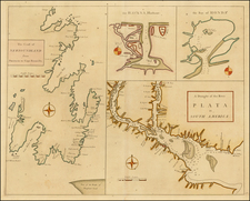
The Scots Settlement in America called New Caledonia, a map of the ill-fated Scottish colony of New Edinburgh, published in London in 1729, stands as a tangible testament to the trials of early colonial endeavors. Based on an original draft by Herman Moll, a prominent geographer of the time, this document provides a captivating glimpse into the transient existence of the Scottish foothold in modern-day Panama.
The map's origin lies in the ambitious plans of William Paterson, the founder of the Bank of England and then Scottish Governor. In 1698, he envisioned the establishment of a colony in Panama as an economic boon for Scotland, leading to the formation of the Company of Scotland. With substantial funds raised, an expedition carrying 1,200 colonists arrived at Darien in November 1698, and the construction of the colony commenced. The region, renamed New Caledonia, was captured in several promotional manuscript maps by English chartmaker William Hacke, from which Moll's printed map derives.
Despite the optimistic beginnings, New Caledonia succumbed to the harsh realities of disease and attacks from Spanish galleons. Within nine months, the remaining colonists had retreated, marking the premature end of the colony. This catastrophic venture pushed Scotland towards economic collapse, culminating in the signing of the Act of Union in 1707, which led to the formation of the United Kingdom.
As an artifact of this historical period, the map also includes an intriguing note, etched in its upper-right corner, that details the geographical characteristics of the Bay of Caledonia, including its rocky ground, the presence of gold, and the rapid regrowth of vegetation in cleared areas. The Scots Settlement in America called New Caledonia thus offers a poignant cartographic memory of a fleeting chapter in colonial history, encapsulating both the high hopes and the grim realities of early colonization attempts.
Herman Moll (c. 1654-1732) was one of the most important London mapmakers in the first half of the eighteenth century. Moll was probably born in Bremen, Germany, around 1654. He moved to London to escape the Scanian Wars. His earliest work was as an engraver for Moses Pitt on the production of the English Atlas, a failed work which landed Pitt in debtor's prison. Moll also engraved for Sir Jonas Moore, Grenville Collins, John Adair, and the Seller & Price firm. He published his first original maps in the early 1680s and had set up his own shop by the 1690s.
Moll's work quickly helped him become a member of a group which congregated at Jonathan's Coffee House at Number 20 Exchange Alley, Cornhill, where speculators met to trade stock. Moll's circle included the scientist Robert Hooke, the archaeologist William Stuckley, the authors Jonathan Swift and Daniel Defoe, and the intellectually-gifted pirates William Dampier, Woodes Rogers and William Hacke. From these contacts, Moll gained a great deal of privileged information that was included in his maps.
Over the course of his career, he published dozens of geographies, atlases, and histories, not to mention numerous sheet maps. His most famous works are Atlas Geographus, a monthly magazine that ran from 1708 to 1717, and The World Described (1715-54). He also frequently made maps for books, including those of Dampier’s publications and Swift’s Gulliver’s Travels. Moll died in 1732. It is likely that his plates passed to another contemporary, Thomas Bowles, after this death.
![[Unusual Italian Immigrant Communities shown!] America Settentrionale, Centrale e Meridionale -- Carta Dimostrativa Delle Ambasciate, Legazioni, Consolati (Con Le Risettive Circoscrizioni Territoriali), Camere Di Commercio, Agenzie Commerciali, Stazion Enotecniche, Uffici Postali, Ospedali, Scuole Governative e Sussidiate All'Estero](https://storage.googleapis.com/raremaps/img/small/86098.jpg)