|
||

|

|
|

|
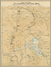
The First Survey and Mapping of Yellowstone Lake
Finely executed map of the area around Yellowstone Lake, which was the product of the diligent surveying efforts of the party led by F.V. Hayden, a U.S. Geologist, in 1871. The map was meticulously compiled and drawn by E. Hergesheimer, referencing the field notes and sketches from A. Schonborn and H.W. Elliott.
The map showcases the expansive Yellowstone Lake, with islands dotted within its vastness and soundings that provide a representation of the lake's depth at different locations. The map also offers a view of the region's intricate water systems, displaying Beaver Dam Creek, Pelican Creek, Yellowstone River, and Upper Yellowstone River. The land's undulating topography is depicted with hachures, while significant landmarks such as Crater Hills, Mt. Doane, Mt. Stevenson, Brimstone Basin, Signall Hills, Rocky Creek, Yellowstone Mountain, Red Mountain, Flat Mountain, and the headwaters of the Snake River are emphasized. Another notable feature is the marking of various hot springs, underscoring the geothermal significance of the region.
While the map itself is an impressive geographical artifact, the story behind its creation is equally fascinating. The Hayden Geological Survey of 1871 embarked on an extensive journey through the heart of what would become Yellowstone National Park. As they traveled, the team meticulously documented their findings. Their journey took them through diverse terrains: from the flowing waters of the Gardner River, the cascading springs of Mammoth Hot Springs, the elevated grounds around Mount Washburn, and the picturesque views from Tower Creek.
One of the expedition's groundbreaking achievements was at Yellowstone Falls, where W. H. Jackson captured the first-ever photographs, preserving its majesty for posterity. Furthermore, the team's innovative spirit was evident when they assembled a boat named "Annie" from packed components, marking it as the first known vessel to navigate the waters of Yellowstone Lake.
During their exploration, the team encountered diverse landscapes and phenomena. They ventured into the geyser basins of the Madison River drainage, traversed the Firehole River to Madison Lake, and skirted around the southern and eastern edges of Yellowstone Lake. Throughout their journey, they consistently documented, sketched, and photographed their surroundings, leaving behind an invaluable repository of information.
The expedition's success was not without challenges. While camped at Steamboat Point, they experienced the unsettling tremors of two significant earthquakes, a reminder of the volatile geothermal underpinnings of the region. Yet, they persisted, sending regular updates about their findings and continuing their pursuit of charting the territory.
The Hayden Party Surveys Yellowstone
The Hayden survey team ventured into the Yellowstone park region on July 21, 1871, beginning their exploration at the Gardner River. Advancing up the river, they arrived at what's now Mammoth Hot Springs, where they spent two days investigating the area. At Mammoth, they discovered that J.C. McCartney and H. R. Horr had claimed 320 acres, even setting up a ranch and bathhouse nearby Liberty Cap. These early settlers eventually established a rudimentary hotel at Mammoth, remaining there for years even after the park's official establishment.
On July 24, the team moved from Mammoth towards Tower Fall, choosing a path closely aligned with today's Mammoth-Tower road. Their route brought them by both Undine Falls and Wraith Falls. By the next day, they made camp at Tower Creek.
From July 25-28, they navigated around Mount Washburn and the Yellowstone River's western edge in Hayden Valley, aiming to reach Yellowstone Lake. It was here that Lt. Gustavus C. Doane took over from Captain Tyler as the military escort's leader. During this leg of their journey, they made camp near Yellowstone Falls, where W. H. Jackson took the falls' first-ever photographs. Later, on July 28, some team members assembled and launched a boat named "Annie" on Yellowstone Lake. This boat, made from parts they carried with them and oars crafted from local trees, was the first known to sail these waters.
Come July 31, while some team members remained at Yellowstone Lake, others ventured back to Hayden Valley. Journeying westward, they aimed for the Madison River's geyser basins, eventually reaching Nez Percé Creek's headwaters and later the Firehole River. They explored the region's various geyser basins extensively before moving on by August 6.
The team traced the Firehole River to Madison Lake, then crossed over to Shoshone Lake, finally making camp near Lost Lake, close to Yellowstone Lake's West Thumb area. On August 7, they set up camp and explored West Thumb for two days. They also sent a batch of specimens and correspondence back to their base camp.
In one such letter, F. V. Hayden wrote to Dr. Spencer Baird of the Smithsonian, discussing their progress, discoveries, and the grandeur of the landscape they encountered. He detailed their navigational methodologies on the lake and their achievements in mapping the region.
From August 9 to 19, the team circled Yellowstone Lake's southern and eastern sides and investigated the Yellowstone River's headwaters. They camped at Steamboat Point on August 19, where they felt significant earthquakes. By August 23, they had stashed away their boat "Annie" and moved northeast. After encountering Pelican Creek, they went on to discover the Lamar River's headwaters. On August 25, they journeyed through the Lamar Valley to the Yellowstone River. Here, they found a bridge constructed by John C. Baronett, the first of its kind over the Yellowstone.
By August 26, most of the survey had exited the park region, camping near Gardiner. They soon met up at Bottler's Ranch, where Dr. Hayden sent another detailed report to Spencer Baird, lauding the team's accomplishments, particularly the artistic and photographic contributions of Henry Elliot.
Ferdinand Vandeveer Hayden, known to the Sioux as "man-who-picks-up-stones-running," stands among the pantheon of eminent geologists of the 19th century.
Hayden's academic career commenced at Oberlin College, and he furthered his education at Albany Medical College, where he received his M.D. in 1853. Despite his medical training, Hayden was primarily engaged in geology, a field to which he would dedicate his life's work.
Hayden commenced his geological career with a survey in the Nebraska Territory in 1856. In 1859 and 1860, he conducted further exploratory work in the Rocky Mountains, particularly in Colorado, which was then part of the Nebraska and Kansas territories. His early work in the field earned him the respect of Native American tribes, with the Sioux reportedly dubbing him "man-who-picks-up-stones-running" due to his avid and energetic collection of geological samples during his expeditions.
By the 1860s, Hayden had risen to prominence as a geologist and was appointed the United States Geologist for the Geological Survey of the Territories. This role would define his career, leading numerous surveys in the Western United States. Notably, from 1871 to 1872, Hayden led a survey into the region that would become Yellowstone National Park, and his reports significantly contributed to the establishment of Yellowstone as the first National Park in 1872.
Hayden's most significant contribution to geological literature was the Geological Atlas of Colorado, published in 1877. This work was the result of comprehensive surveys conducted across Colorado, meticulously documenting the state's geography and geology. The atlas offered detailed maps on a scale previously unseen, encompassing not only Colorado but adjacent areas, including parts of Utah, Arizona, and New Mexico.
Hayden's influence extended to academia, as he was affiliated with the University of Pennsylvania for a period, where he held the position of professor of geology. His academic and field work combined to form a substantial body of knowledge that would be used by future scholars and explorers.
Ferdinand V. Hayden passed away on December 22, 1887, in Philadelphia, Pennsylvania. His enduring legacy is reflected in the numerous natural features named after him, including Hayden Valley in Yellowstone and Mount Hayden in Colorado. His contributions to geology during the 19th century remain a cornerstone of American geological and geographical sciences.

![[ Utah Territory and the Great Plains ] Maps / Stansbury's Expedition / Map of the Great Salt Lake and Adjacent Country in the Territory of Utah . . . (and) Map of a Reconnaissance between Fort Leavenworth on the Missouri River and the Great Salt Lake of Utah made in 1849 and 1850 . . .](https://storage.googleapis.com/raremaps/img/small/83532.jpg)
![Map of Oregon, Washington and Part of Idaho [First Appearance Of Idaho Territory, including western Montana and Western Wyoming]](https://storage.googleapis.com/raremaps/img/small/94211.jpg)