|
||

|

|
|

|
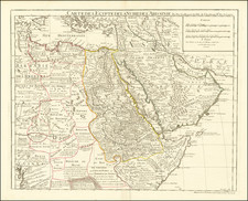
French Trade on the Swahili Coast, During the Birth of that Country's Slave Trade in the Region.
Anonymous French manuscript map of Mombasa Island, likely created by an early French slaver sailing on Omani-controlled East Africa in the mid-18th century.
Mombasa, long one of the most important ports on the east coast of Africa, represented the primary site of cultural exchange between Swahili peoples at the time. In addition to the Indian Ocean trade that saw the region producing timber, ivory, animal skins, spices, and gold since at least the first century, Europeans became involved in the slave trade in the 15th century. French slave traders are recorded as active in the region from 1721 onwards.
The map is anonymous, but the quality of its execution suggests that an experienced navigator drew it. Given the time frame, the most likely explanation is that it was created by a French slaver preparing to sail on the Omani-controlled port of Mombasa between 1742 and 1749. The French involvement in the region started in 1721, with a chance encounter between the Portuguese Count of Ericeira and French settlers in Isle Bourbon (Reunion), which led to cooperation between the two against piracy in East Africa. However, rapid growth did not come until 1735 and the involvement of Bertrand-François Mahé de La Bourdonnais, a French officer who had previously served in the Portuguese navy. Portuguese attitudes towards the French were highly erratic during this period, which allowed for the steady growth of French trade in the area. The present manuscript was almost certainly produced as part of this growth.
French Involvement on the Swahili Coast in the 18th Century
Of the European powers, only France and Portugal entertained serious mercantile ambitions in East Africa during the first half of the 18th century. British interest in this region was primarily a Victorian phenomenon, and the British colonization of Kenya did not begin in earnest until 1901.
The French, particularly under La Bourdonnais, showed a keen interest in expanding their trade with East Africa. On two occasions, in 1739 and 1744, the Compagnie des Indes, with the support of the French Court, requested that Portugal relinquish all or part of its territorial claims north of Cape Delgado. Both requests were refused by D. Joao V, the King of Portugal. The Portuguese still harbored ambitions of recapturing Mombasa. Rumors even circulated in Lisbon that the French had captured Moçambique by surprise, but these were later debunked.
However, for practical purposes, French slavers were the only Europeans to consistently trade with the Omani Sultanate in Mombasa after the Portuguese were expelled in 1729. Between 1735 and 1770, French trade - especially in slaves - boomed. Our map, which shows the island of Mombasa, including the surrounding headlands and the maritime approach, was likely drawn as a preparatory measure for a slaving expedition. With the third book of The English Pilot hitting the market a year before this trade took off, it makes sense that the cartographer behind the manuscript map adapted it from the most seminal nautical atlas of the age.
A History of the Mapping of Mombasa
There are multiple 16th-century depictions of Mombasa, including a city view published in Braun and Hogenberg's famous city atlas Civitates Orbis Terrarum from 1572. But these were largely schematic in their rendition. A more detailed map of the island, which included the first depth soundings, was produced by the Portuguese hydrographer João Teixeira Albernaz, who created his maps before the Omani Sultanate expelled the Portuguese from Mombasa in 1698. Among his enormous output, Teixeira produced an important map of the East African coastline with three detailed insets of African ports, one of them Mombasa. The inset included important navigational information such as depth soundings, which Teixeira had access to as hydrographer to the Spanish and Portuguese kings (Phillip III and João IV, respectively). When Teixeira's map was published around 1672, it was nevertheless by the French polymath Melchisédec Thévenot. In this way, nautical information on East Africa passed from the Portuguese sphere of cartographic awareness to that of the French.
The earliest French map of Mombasa Island was by Pierre Mortier, which Jaillot published in a new edition of the Atlas Nouveau in 1708. As in Teixeira's map, Mombasa figured as an inset on a larger map of the Red Sea and Zanzibar coast (Carte Particuliere de la Mer Rouge). Its inclusion reflected a growing French commercial interest in East Africa - especially for slaves. However, a dedicated map of the island was not published until Jacques-Nicolas Bellin's map in L'Abbe Prévost's Histoire Générale des Voyages (1749). Within the repertoire of French cartography, these two maps form chronological bookends to our remarkable chart.
Our manuscript map was compiled as a practical document that noted crucial nautical information such as shallows and depth soundings. Studying these, we note that the numbers on our chart differ from those on the Mortier/Jaillot map but match the numbers on Bellin's map. The primary source for the Mortier map seems to be Thévenot's publication of Teixeira, for everything - from soundings and placenames to the features included - is identical to Teixeira's map. In comparison, our chart (and the Bellin map) contain a completely different dataset.
The best map of Mombasa to date, and clearly the map that helped to inform the present manuscript, was the 1734 Samuel Thornton inset map that appeared in that year's edition of The English Pilot, Third Book. Thornton applies the same upside-down orientation as our manuscript map, in which south is at the top. He also applied a number of updates to the cartography, including naming additional features on the island and including additional soundings. Thornton's map would be adapted by reduced by Nicolas Bellin for his hydrographical atlas.
Watermark and Dating
The paper is watermarked with "B★C★RICHARD," corresponding to Bernstein 0019272A, 0019300A, and 0019307A. This paper was manufactured in Auvergne and its use is traced to between 1742 and 1749, thus providing a narrow range for the production of this map.
(https://doi.org/10.3406/cea.1970.2845)
Monique de la Roncière (1965). Manuscript Charts by John Thornton, Hydrographer of the East India Company (1669-1701). Imago Mundi 19: 46–50. (http://www.jstor.org/stable/1150328)
Thomas Vernet (2009). Slave trade and slavery on the Swahili coast (1500-1750). In Slavery, Islam and Diaspora, pp.37-76.Edited by B.A. Mirzai, I.M. Montana et P. Lovejoy. Africa World Press.