|
||

|

|
|

|
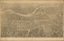
Elevation Overprint Example.
Scarce large-scale map of London and environs by the famed London mapmaker James Wyld. The map covers the area between Tottenham, West Ham, Streatham, and Ealing.
This is an interesting overprint version of the map in which altitudes around the region have been printed in red. A note at the top explains "Levels taken by order of the Commissioners of Sewers" and a further explanation in the lower right says "NOTE. The altitudes are given in feet above the approximate mean water at Liverpool being 12 ½ feet below Trinity High Water mark." The Trinity High Water (THW) mark is a specific standard used in the UK for measuring tidal levels and hence, indirectly, for determining altitudes. This statement indicates that the reference point (the approximate mean water level at Liverpool) is 12.5 feet (12 and a half feet) below the THW mark.
The elevations generally work their way up to the highest points in Hempstead and Highgate.
James Wyld Sr. (1790-1836) was a British cartographer and one of Europe’s leading mapmakers. He made many contributions to cartography, including the introduction of lithography into map printing in 1812.
William Faden, another celebrated cartographer, passed down his mapmaking business to Wyld in 1823. The quality and quantity of Faden’s maps, combined with Wyld’s considerable skill, brought Wyld great prestige.
Wyld was named geographer to Kings George IV and William IV, as well as HRH the Duke of York. In 1825, he was elected an Associate of the Institution of Civil Engineers. He was one of the founding members of the Royal Geographical Society in 1830. Also in 1830, his son, James Wyld Jr., took over his publishing house. Wyld Sr. died of overwork on October 14, 1836.
James Wyld Jr. (1812-87) was a renowned cartographer in his own right and he successfully carried on his father’s business. He gained the title of Geographer to the Queen and H.R.H. Prince Albert. Punch (1850) described him in humorous cartographic terms, “If Mr. Wyld’s brain should be ever discovered (we will be bound he has a Map of it inside his hat), we should like to have a peep at it, for we have a suspicion that the two hemispheres must be printed, varnished, and glazed, exactly like a pair of globes.”
![[View of London, etc.] Abilltung wie königliche Maistät in Engelandt Die Artickel Dess Spanischen Heyraths Jur: Bekreftiget Anno 1623](https://storage.googleapis.com/raremaps/img/small/90777.jpg)
![[London] Redriffe and Part of St. Mary Magdalens Parish Southwark Taken from ye Latest Survey with Corrections](https://storage.googleapis.com/raremaps/img/small/70290.jpg)