|
||

|

|
|

|
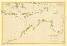
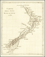
This 1800 chart of the western Pacific Ocean serves as a testament to the vigorous exploratory efforts characterizing the maritime expeditions of the British Empire at the turn of the 19th century. Created under the guidance of Captain Butler of the Walpole, the chart meticulously records the routes and findings of various British vessels across the southwestern Pacific, from New Zealand to the eastern coast of Australia and northward.
The era this chart represents was marked by a rapid escalation in global exploration and cartographic documentation. The British Empire, in its quest to claim and understand the farthest reaches of the globe, and in particular Australia in this instance, dispatched numerous maritime expeditions. These voyages are traced in the lines and notations across the chart, revealing Britain's ambitious initiative to uncover the mysteries of the southwestern Pacific.
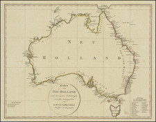
The geographical scope of the chart is expansive, featuring several key regions. It covers most of New Zealand, the eastern coast of Australia as known during the early 19th century, New Caledonia, the New Hebrides, the Solomon Islands, and an exploratory interpretation of the eastern half of New Guinea. In addition, the Ladrone and New Caroline Islands are depicted.
Each of these regions is depicted with careful detail, indicating a strong commitment to navigational accuracy and a clear recording of the explorers' observations. Inset charts and annotations are incorporated to supplement the main geographical depiction, providing additional insight into the voyages and findings.
The chart's visual features also include engraved coastal profiles, aiding in the understanding of the terrain. The data collected through lunar observations and the chronometer corrections reveal the methodologies used in that era for maintaining the accuracy of the charted routes.
Beyond the geographical and navigational details, the chart also includes an array of text references. These provide a unique glimpse into the actual voyage of the Walpole and other vessels, giving it a degree of authenticity and historical significance beyond just being a cartographic record.
Rarity
Very rare. OCLC locates only examples in the National Library of Australia. It is difficult to decipher how many examples are held there, but it appears not more than three.
There was an edition published in 1799 (not in Tooley), 1800 (Tooley 275), and in 1822 (by Richard Holmes Laurie, Tooley 276).
Robert Laurie (ca. 1755-1836) and James Whittle (1757-1818) formed their Fleet Street, London-based firm upon the 1794 death of their employer Robert Sayer, himself one of the dominant print and mapmakers of the last half of the 18th century.
Laurie & Whittle started managing Sayer's business as early as 1787. They took over all managerial duties when Sayer's health flagged in 1792, and they changed the imprint in 1794 upon his death. Sayer left the two a 21-year lease on the shop (at £100 a year) and on Sayer's Bolt Court premises, as well as an option to acquire stock and equipment at a preferential price of £5,000 payable over three years.
Robert Laurie retired from the firm in 1812, and his role was assumed by his son, Richard Holmes Laurie (1777-1858). The younger Laurie worked with James Whittle until the latter died in 1818. After R. H. Laurie died in 1858, Alexander George Findlay, FRGS (1812-1875) purchased the firm from his daughters. The firm continues today under another name, specializing in yachting charts.
Laurie & Whittle were prolific print and map publishers, and throughout their careers, they produced numerous very important and rare works. They carried on Robert Sayer's atlas business and were responsible for editions of The Complete East-India Pilot and The American Atlas.