|
||

|

|
|

|
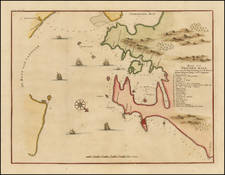
Rare English sea chart the harbor of Galle, published Laurie & Whittle, in 1798. The chart includes soundings, anchorages and notes on sailing in and out of the harbor
Laurie and Whittle's sea chart offers a fine depiction of the area around Galle
Laurie and Whittle's chart includes numerous of depth soundings, anchorages and shallow waters.
The chart appeared in an important pilot book, which includes charts facilitating sailing along the route from England to the Far East, including coverage of the east coast of Africa, Arabia, Persia, the Indian sub-continent, South-East Asia and the East Indies and on to the Far East, with China and Japan.
Galle
In the 18th century, Galle, situated on the southwestern tip of Sri Lanka, was a focal point of geopolitical interests and maritime trade. According to James Emerson Tennent, Galle's antiquity as a seaport could be traced back to the times of King Solomon. However, the 18th century was particularly significant for the port city because it marked the end of Dutch colonial rule and the advent of the British era. The Dutch had held the fort at Galle since 1640, fortifying it substantially in 1663 with solid granite walls and three bastions named "Sun," "Moon," and "Star." Dutch rule was to be supplanted by British control in 1796, a transition that culminated in a significant naval conflict.
On February 23, 1796, the 70th Regiment of British Forces in what was then Ceylon, under the command of Captain Locklan Macwary, assumed control over Galle without encountering resistance. The administrative oversight of Ceylon was initially the responsibility of the British Governor based in Madras until October 1798. Administrative complexities necessitated a more localized governance structure, culminating in the royal proclamation on October 12, 1798, that appointed Sir Fredrick North as Governor and Commander in Chief of the British territory of Sri Lanka. This moment also signified the inauguration of the Ceylon Civil Service.
The East-India Pilot Publications
Laurie & Whittle's general pilot covering the sea journey to the East Indies (following Sayer & Bennett's before them) was published under several titles, often in the same year, each with a different complement of charts. The usual titles include: The Complete East-India Pilot, or Oriental Navigator, which was typically a larger, two-volume work; The East-India Pilot, or Oriental Navigator, also often quite large -- extending to over 100 charts in some of the 1790s editions; and The Oriental Pilot; Or, East-India Directory, usually a single volume work focusing on the most important charts used for the journey.
The scholarship for all editions of the book is quite incomplete; as far as we are aware, no bibliography provides anything like a comprehensive treatment of the pilots. This is due, in no small part, to the extreme rarity of all volumes from the series.
These atlases were published in a mode that was very different from many late 18th century atlases that were intended for a broad market. Laurie & Whittle's pilots were expensive utilitarian objects. They were intended for use by actual sea captains and navigators who were plotting routes to the East Indies aboard Royal Navy vessels or East Indiamen. Thus buying market was very small, and the damage accrued to the books during use at sea must have been considerable.
Robert Laurie (ca. 1755-1836) and James Whittle (1757-1818) formed their Fleet Street, London-based firm upon the 1794 death of their employer Robert Sayer, himself one of the dominant print and mapmakers of the last half of the 18th century.
Laurie & Whittle started managing Sayer's business as early as 1787. They took over all managerial duties when Sayer's health flagged in 1792, and they changed the imprint in 1794 upon his death. Sayer left the two a 21-year lease on the shop (at £100 a year) and on Sayer's Bolt Court premises, as well as an option to acquire stock and equipment at a preferential price of £5,000 payable over three years.
Robert Laurie retired from the firm in 1812, and his role was assumed by his son, Richard Holmes Laurie (1777-1858). The younger Laurie worked with James Whittle until the latter died in 1818. After R. H. Laurie died in 1858, Alexander George Findlay, FRGS (1812-1875) purchased the firm from his daughters. The firm continues today under another name, specializing in yachting charts.
Laurie & Whittle were prolific print and map publishers, and throughout their careers, they produced numerous very important and rare works. They carried on Robert Sayer's atlas business and were responsible for editions of The Complete East-India Pilot and The American Atlas.
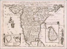
![[Sri Lanka] Tabula Asiae XII](https://storage.googleapis.com/raremaps/img/small/87852.jpg)
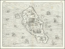
![[ Taprobana / Sri Lanka ] Duodecima Asie Tabula](https://storage.googleapis.com/raremaps/img/small/101258.jpg)