|
||

|

|
|

|
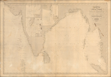
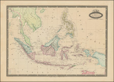
Rare English sea chart of the Malaysian coast centered mouth of the Selangor River, published Laurie & Whittle, in 1796. The chart includes soundings, anchorages and extensive sailing directions for the Straits of Colong.
Laurie and Whittle's sea chart offers a fine depiction of the Selangor coast and the Strait of Malacca, located on the western seaboard of what is now Malaysia. The chart extends its geographical coverage from Point Caran—today known as Tanjong Karang—to Parcelar Hill, presently referred to as Banting. The Islands of Poolo Colong, Colong or Cal, and Poola Loomaut are also delineated, now identifiable as Pulau Ketam, Pulau Klang, and Pulau Lumut, respectively. Along the right margin, a pair of coastal profile views detail the Road of Selangor.
The sailing directions beneath the title offer intricate sailing directives for what is now known as the Sungai Tiga Strait. Kuala Selangor, a contemporary town and the modern capital of Selangor, emerges in historical context as a Dutch trading outpost dating from circa 1784. Although Kuala Lumpur was not yet established, the map serves as an early representation of the coastline that would eventually develop into the modern ports of Klang and Kelang.
Laurie and Whittle's chart includes dozens of depth soundings, commentary on undersea terrain and reefs, and the inclusion of navigational aids such as rhumb lines and shoals. Place names are copiously documented, delivering a wealth of information for mariners of the period.
The mapis based upon the work of French cartographer Jean-Baptiste d'Apres de Mannevillette with corrections based on English draughts.
The chart appeared in an important pilot book, which includes charts facilitating sailing along the route from England to the Far East, including coverage of the east coast of Africa, Arabia, Persia, the Indian sub-continent, South-East Asia and the East Indies and on to the Far East, with China and Japan.
Selangor
After the fall of Malacca to the Portuguese in 1511, the area came under the control of the Johor Sultanate and was later governed by Sri Agar Diraja, a member of the Bendahara family of Johor. In the 17th century, the region became a theater of conflict as Johor engaged in warfare against Jambi. To bolster its forces, the Sultan of Johor enlisted the aid of Bugis mercenaries from Sulawesi. Following Johor's victory in 1679, these Bugis warriors chose to remain, thereby starting to exert influence and power in the region. Many of them migrated and settled along the coast of Selangor, specifically in the estuaries of the Selangor and Klang rivers.
During the same period, there were also arrivals of some Minangkabaus, possibly as early as the 17th century. The stage was set for a protracted struggle for control between the Bugis and the Minangkabaus from Sumatra. Raja Kecil, backed by the Minangkabaus, invaded Selangor but was repelled by the Bugis in 1742. Cementing their influence, the Bugis, under the leadership of Raja Salehuddin, founded the hereditary Selangor Sultanate in 1766, establishing its capital at Kuala Selangor. This unique historical evolution distinguishes Selangor as the only state on the Malay Peninsula founded by the Bugis.
Robert Laurie (ca. 1755-1836) and James Whittle (1757-1818) formed their Fleet Street, London-based firm upon the 1794 death of their employer Robert Sayer, himself one of the dominant print and mapmakers of the last half of the 18th century.
Laurie & Whittle started managing Sayer's business as early as 1787. They took over all managerial duties when Sayer's health flagged in 1792, and they changed the imprint in 1794 upon his death. Sayer left the two a 21-year lease on the shop (at £100 a year) and on Sayer's Bolt Court premises, as well as an option to acquire stock and equipment at a preferential price of £5,000 payable over three years.
Robert Laurie retired from the firm in 1812, and his role was assumed by his son, Richard Holmes Laurie (1777-1858). The younger Laurie worked with James Whittle until the latter died in 1818. After R. H. Laurie died in 1858, Alexander George Findlay, FRGS (1812-1875) purchased the firm from his daughters. The firm continues today under another name, specializing in yachting charts.
Laurie & Whittle were prolific print and map publishers, and throughout their careers, they produced numerous very important and rare works. They carried on Robert Sayer's atlas business and were responsible for editions of The Complete East-India Pilot and The American Atlas.