


|
||

|

|
|

|
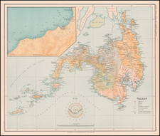
Coastal Charts of Two Portions of the Philippine Islands: A Navigational Insight from 1794
Fine pair of coastal charts of portions of Luzon Island and Mindanao Island, part of the Philippines archipelago.
The islands are famed for its rich maritime history, and strategic significance in sea trade and navigation and have been a subject of interest to explorers, traders, and cartographers, aiming to understand its intricate coastline for safe and profitable navigation.
Plan of Solsogon Harbor on the South Coast of Luconia (Luzon)
The first chart offers a detailed layout of the Solsogon Harbour. Solsogon (Sorsogon) is located at the southern tip of the Bicol Peninsula of Luzon. Sorsogon has always been a crucial point of maritime interest because of its strategic location. Its bay area provides a natural harbor, which has historically been used for trade, fishing, and as a vantage point against potential sea-based threats.The chart includes soundings and rhumblines, straight navigational paths that would be followed using a constant compass bearing. The addition of several anchorages signified safe locations for ships to anchor and probably rest or make repairs.
Chart on the Eastern Coast of Bongo Bay in the Island of Mindanao
Bongo Bay in Mindanao is depicted in the second chart, providing a glimpse into the geographical challenges and opportunities along its eastern coast. Particularly intriguing is the inclusion of a reef located between Tubok and Tabongen. Reefs are natural barriers that can pose risks to navigation. Recognizing them in navigational charts is vital for sailors to circumvent potential dangers. Additionally, the chart indicates places along the coast where fresh water and wood – two essential resources for long voyages – could be procured. The presence of these spots painted a picture of how explorers and traders would interact with the environment, using it to replenish their supplies.
Both charts, derived from British explorations, bear testament to the British Empire's active involvement in Southeast Asia. The Philippines, being at the crossroads of major sea routes, naturally became a subject of interest. These detailed charts not only provided invaluable navigational insights but also reflected the larger geopolitical and commercial aspirations of the British during that period.
Robert Laurie (ca. 1755-1836) and James Whittle (1757-1818) formed their Fleet Street, London-based firm upon the 1794 death of their employer Robert Sayer, himself one of the dominant print and mapmakers of the last half of the 18th century.
Laurie & Whittle started managing Sayer's business as early as 1787. They took over all managerial duties when Sayer's health flagged in 1792, and they changed the imprint in 1794 upon his death. Sayer left the two a 21-year lease on the shop (at £100 a year) and on Sayer's Bolt Court premises, as well as an option to acquire stock and equipment at a preferential price of £5,000 payable over three years.
Robert Laurie retired from the firm in 1812, and his role was assumed by his son, Richard Holmes Laurie (1777-1858). The younger Laurie worked with James Whittle until the latter died in 1818. After R. H. Laurie died in 1858, Alexander George Findlay, FRGS (1812-1875) purchased the firm from his daughters. The firm continues today under another name, specializing in yachting charts.
Laurie & Whittle were prolific print and map publishers, and throughout their careers, they produced numerous very important and rare works. They carried on Robert Sayer's atlas business and were responsible for editions of The Complete East-India Pilot and The American Atlas.
![[ Philippine Islands & Spice Islands ] Isles Philippines et Moluques . . .](https://storage.googleapis.com/raremaps/img/small/99646.jpg)
![[Philippine Islands, Taiwan, etc] Partie des Isles Philippines; Partie de la Chine; Partie de L'Ile Gilolo; Partie de L'Isle Borneo](https://storage.googleapis.com/raremaps/img/small/93579.jpg)
![Les Isles Philippines Molucques et de La Sonde [Japan inset]](https://storage.googleapis.com/raremaps/img/small/69697.jpg)