


|
||

|

|
|

|
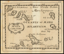
Striking set of 4 maps on a single sheet, published by Thomson.
Includes a beautiful vignette of Tenerife in the center and detailed maps of the Madeira, Azores, Canary, and Cape Verde Islands. On each map with longitude measured from Ferro or the Prime Meridian; the island of Ferro is shown on the Canary Islands map. An inset shows Porto Pim, the Igreja de Santa Catarina de Alexandria, and Forte de Santa Cruz on Faial. A second inset shows Arrecife Bay, with Castillo de San Gabriel, on Lanzarote.
John Thomson (1777-ca. 1840) was a commercial map publisher active in Edinburgh. He specialized in guide books and atlases and is primarily known for his Atlas of Scotland (1832) and the New General Atlas, first published in 1817 and reissued for the next quarter century. The New General Atlas was a commercial success—it was also published in Dublin and London—and it compiled existing geographic knowledge in compelling ways for a wide audience.
His Atlas of Scotland introduced new geographic information and was the first large-scale atlas of Scotland to be organized by county. It provided the most-accurate view of Scotland available before the Clearances. Work on the atlas began in 1820 and led to Thomson’s bankruptcy in 1830 due to the high costs of gathering the latest surveys and reviewing the required materials. Despite the publication of the atlas, Thomson declared bankruptcy again in 1835.
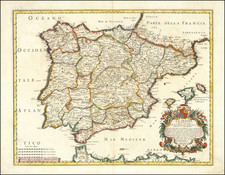
![[ Rare Imprint ] Hispania ex Archetypo Roderici Mendez Sylvae et variis Relationibus manuscriptis et impressis hujus Regni . . . .](https://storage.googleapis.com/raremaps/img/small/104150.jpg)