|
||

|

|
|

|
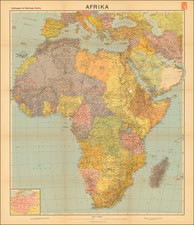
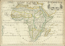
A fine example of Daniel Lizars' four-sheet map of Africa, an intriguing snapshot of the expanding frontiers of European knowledge during the early 19th century. Compiled around 1825, the map reveals the contours of the continent as they were understood by European cartographers of the period, a juxtaposition of extensive detail along the coasts and vast, intriguingly blank spaces in the interior.
The coastal lines of Africa are meticulously plotted, a testament to rigorous scientific mapping carried out by various European expeditions. Yet, the dearth of information about the continent's interior underscores the mystery and intrigue that Africa held for European explorers. The great swathes of uncharted territories offer a stark reminder of the geographical unknowns that still persisted in an era characterized by rapid exploration and colonial expansion.
Noteworthy are the few incursions into the continent's interior, most of which were concentrated in regions under European colonial influence. These include South Africa, where Dutch and British explorers ventured inland, as well as Mozambique, Angola, and the Congo, where Portuguese expeditions had managed to map parts of the interior. Other areas that saw some exploration were the Lower Nile Valley, the focus of French and British efforts, and certain regions of West Africa.
The explorations in West Africa, though not as extensive, were particularly significant. The Africa Association, established in London in 1788, sponsored numerous expeditions to navigate the Niger and Gambia rivers, fueled by the hope of discovering the fabled city of Timbuktu, a key trading hub in African lore. The most prominent figure in these efforts was Mungo Park, whose expeditions from 1795 to 1806 filled in a crescent of detail cutting across the map's empty space in West Africa. However, despite these British endeavors, it was French explorers such as René Caillié, working for the Société de Géographie, who would ultimately reach Timbuktu and cement French dominance over the interior of West Africa.
Lizars' map provides invaluable insights into how Africa was perceived and understood in the early 19th century, capturing the shifting frontier between the known and the unknown, and the ambitious undertakings that sought to illuminate the continent's mysteries.
The Lizars were a Scottish family of engravers and printers who produced many views and maps. Daniel Lizars Sr. (1754-1812) was the son of a shoemaker, but he apprenticed with Andrew Bell, a printer and engraver. Lizars set up his own printworks near St. Giles Cathedral and took on his own apprentices, including George Bartholomew, whose son John would go on to found the important mapmaking firm later know as John Bartholomew & Son Ltd.
Daniel Sr. had three sons: Daniel Jr., John, and William Home. He also had a daughter, Jane Home. Daniel Jr. (1793-1875), the youngest of the boys, apprenticed in his father’s shop alongside George Bartholomew. When his father died in 1812, Daniel Jr. took over much of the business, expanding it and specializing in maps. The company went bankrupt in 1832, however, and Daniel emigrated to Canada.
John Lizars (1792-1860), the middle son, studied medicine and became Professor of Surgery at the Royal College of Surgeons of Edinburgh, as well as senior surgeon at the Royal Infirmary of Edinburgh.
William Home Lizars (1788-1859), the eldest, also apprenticed in his father’s shop. After learning engraving, William entered the Trustees’ Academy to learn under John Graham. He was a skilled painter and artist. When his father died, and after his Daniel Jr. left, he carried on printing and invented a method of etching that looks like wood engraving.