|
||

|

|
|

|
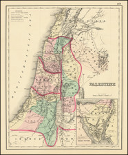
Survey of Palestine Motor Map Second Edition 1:500,000 is an extremely detailed map primarily meant to serve travelers, and individuals interested in the region's geography and historical sites.
The map is marked with insets of significant cities of Haifa, Jerusalem, and Jaffa & Tel Aviv, providing more detailed representations of these urban areas. Various features such as first and second class motor roads, railway stations, post offices, churches, mosques, synagogues, police stations, cemeteries, and even civil aircraft landing grounds are meticulously documented. Ancient sites of interest, such as Lachish, are clearly highlighted.
To assist in navigational purposes, the map includes features such as international boundaries, district & sub-district boundaries, military & emergency landing grounds. Certain geographical attributes are also included, such as the depiction of wadis, which are dry except during rains.
The map employs a grid system for easier navigation, with grid squares labeled with letters and numbers in the margin. For example, Jerusalem is located in square J.5. The grid lines refer to Survey Palestine coordinates and are numbered every 20 kilometers east and north of an origin outside the country to the southwest. This system allows users to pinpoint exact locations by measuring distances from the grid lines.
Road information is explicitly stated as not guaranteed since conditions can change. The map also considers weather factors, as it highlights dry weather tracks and roads that can become impassable after heavy rain.
The heights are measured in meters, and all the distances between locations are mentioned in kilometers. The roads' gradients are also indicated, with no gradient on the principal roads exceeding 1 in 6½.
As a whole, this map provides a comprehensive guide to the physical and political landscape of Palestine, useful for various purposes from travel planning to historical research.
![[Poster] Keep the Promise The Israel Emergency Fund](https://storage.googleapis.com/raremaps/img/small/78786.jpg)
![[Cyprus, Holy Land, Syria Middle East] Tabula Asiae IIII](https://storage.googleapis.com/raremaps/img/small/100937.jpg)