|
||

|

|
|

|
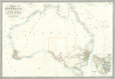
The Greatest 18th-Century British Chart of Australia.
A New Chart of the Eastern Coast of New Holland, published by Laurie & Whittle in London in 1798, presents a detailed portrayal of the nascent understanding of the Australian coastal regions as charted by notable explorers such as Abel Jansen Tasman, Tobias Furneaux, and Captain James Cook. The mapping of these coastal areas provided critical navigation information for maritime voyages and would become integral to the development of British colonial interests in the region.
The chart in question came about in a time of relentless exploration, particularly in the Southern Hemisphere. The Dutch explorer Abel Jansen Tasman, who undertook voyages in 1642, made the initial discovery of Van Diemen's Land—what we now know as Tasmania. Furneaux would explore it further in 1773, and Cook would visit in 1777. Still, the concept of Tasmania as a separate landmass would not solidify until Matthew Flinders circumnavigated the island in 1798-99, validating Tasman and Furneaux's initial findings.
The chart is uniquely comprehensive for its era, tracing Cook's journey in painstaking detail. It includes a host of insets and annotations providing a variety of geographical and navigational details. These additional materials include details of local waterways, harbors, and coastal landmarks. There are instructions for navigating to Port Jackson (now Sydney Harbour), and a section illustrating the intended settlement, labeled as the "County of Cumberland."
Moreover, the chart reflects the incompleteness of geographical knowledge during the 18th century. The tentative lines marking a "Conjectural Coast" on the west side of Van Diemen's Land reveal the tentative grasp explorers had on the geography of this new world. On the east coast of present-day Tasmania (really in the Bass Strait), a mysterious "Parts which are absolutely unknown" label underscores the vast swathes of uncharted territory that remained to be discovered.
This map was produced against the backdrop of Captain James Cook's voyages, which significantly advanced British understanding of the Pacific, leading to the colonization of Australia. Cook's 1770 journey, during which he charted the east coast of Australia, notably including Botany Bay, set the stage for the establishment of a penal colony in 1788, marking the beginning of permanent European settlement on the continent.
However, this map was not merely a utilitarian tool for navigation. It stands as an artifact that records and makes visible the process of discovery and exploration. It also serves as a testament to the rising British naval supremacy and the extension of its colonial interests. The detailed annotations on sailing instructions, tide times, and landmarks, reveal the extent to which Britain was preparing for further exploration and eventual settlement in these far-flung lands.
Cook's meticulously detailed track from New Zealand, as portrayed in this chart, encapsulates the concerted efforts undertaken by the British to systematically chart and, in effect, claim this territory. His voyage's objective was twofold: to observe the Transit of Venus across the Sun—an astronomical event that would help determine the Earth's distance from the Sun—and to seek out Terra Australis Incognita, the speculative southern continent that had eluded European explorers for centuries. His discoveries would ultimately disprove the existence of this mythical landmass and instead reveal the reality of Australia and New Zealand.
In the broader context, this chart is an artifact of a pivotal moment in the history of Australia. In the decades following its creation, the British would solidify their presence in the region, initiating a profound transformation of the land and its people. The development of the penal colonies, the burgeoning free settlements, and the eventual discovery of gold would reshape Australia and create the foundation for the modern nation we know today.
Insets and Coastal Profiles
Insets:
- "The Coast of New South Wales from Cape Tribulation to Endeavour Straits Shewing THE LABYRINTH &ca on a Larger Scale with the Tracks of CAPTN. COOK & LIEUT. BLIGH"
- "Entrance of Endeavour River"
- "Botany Bay"
- "Port Jackson"
- "Sidney Cove"
- "A Particular Chart of the Southernmost Part of New Holland"
- "Adventure Bay"
Coastal profiles:
- "Appearance of Van Diemen's Land over Fluted Cape, when South Cape bears NNE.E distant 7 Miles."
- "Appearance of the Land over Fluted Cape when Penguin Island bears N.Wby W12 Miles dist!"
- "Appearance of Van Diemen's Land the Mewstone bearing N2E dist. 5 Miles."
- "View of the South Side of Adventure Bay"
Rarity
The chart was originally issued by Robert Sayer on June 4th, 1787. That edition lacks the insets of Port Jackson and Sydney. Also in this edition, Torres Strait and the tip of New Guinea have been revised based on the information from the Pandora Captain Edwards in 1791, and the Hormuzear, of Captain Bampton in 1793.
There is also a 1790 issue which is not listed by Tooley.
Robert Laurie (ca. 1755-1836) and James Whittle (1757-1818) formed their Fleet Street, London-based firm upon the 1794 death of their employer Robert Sayer, himself one of the dominant print and mapmakers of the last half of the 18th century.
Laurie & Whittle started managing Sayer's business as early as 1787. They took over all managerial duties when Sayer's health flagged in 1792, and they changed the imprint in 1794 upon his death. Sayer left the two a 21-year lease on the shop (at £100 a year) and on Sayer's Bolt Court premises, as well as an option to acquire stock and equipment at a preferential price of £5,000 payable over three years.
Robert Laurie retired from the firm in 1812, and his role was assumed by his son, Richard Holmes Laurie (1777-1858). The younger Laurie worked with James Whittle until the latter died in 1818. After R. H. Laurie died in 1858, Alexander George Findlay, FRGS (1812-1875) purchased the firm from his daughters. The firm continues today under another name, specializing in yachting charts.
Laurie & Whittle were prolific print and map publishers, and throughout their careers, they produced numerous very important and rare works. They carried on Robert Sayer's atlas business and were responsible for editions of The Complete East-India Pilot and The American Atlas.
![[ The Ptolemaic Universe ] Situs Terrae Circulis Coelestibus Circundatae . . .](https://storage.googleapis.com/raremaps/img/small/101512.jpg)
![(Sydney) Plan du Comte de Cumberland (Nouvelle-Galles du Sud) [on sheet with] Plan des Iles Jerome [and] Plan des Iles Berthier](https://storage.googleapis.com/raremaps/img/small/77740.jpg)