|
||

|

|
|

|
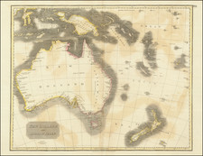
A Chart of Van Diemen's Land, the South Extremity of New Holland, with the New-Discovered River by the Ships Duke and Duchess, is an illustrative representation of late 18th-century maritime exploration. Published in 1798 by Laurie & Whittle, the chart meticulously depicts the southern reaches of what is now known as Tasmania, alongside a large inset showcasing the continuation of a newly discovered river from King George's Bay.
This chart embodies the spirit of maritime exploration and discovery at the close of the 18th century. It was during this period that European explorers ventured further into the Southern Hemisphere, often mapping and naming places hitherto unknown to them. Van Diemen's Land, now Tasmania, and New Holland, present-day Australia, were particularly significant regions of exploration and subsequent colonial interest.
The chart includes an inset that offers a detailed depiction of the continuation of a river originating from King George's Bay. This feature not only enriches the geographical detail of the chart but also encapsulates the historical moment of discovery, even showing the location of the ships Duke and Duchess at anchor.
Geographical labeling within the chart signifies the territorial aspirations of the British Empire, renaming the coastlines as New Cumberland and New Yorkshire and illustrating William Pitt's Island. Such naming patterns, common among European explorers, reflected the desire to establish symbolic control over the new lands being mapped.
In summary, the Chart of Van Diemen's Land, the South Extremity of New Holland, with the New-Discovered River by the Ships Duke and Duchess provides an invaluable window into the age of exploration. Beyond its geographical accuracy and detailed depictions, it serves as a record of British maritime discovery and the broader imperial ambitions that drove such explorations at the end of the 18th century.
Robert Laurie (ca. 1755-1836) and James Whittle (1757-1818) formed their Fleet Street, London-based firm upon the 1794 death of their employer Robert Sayer, himself one of the dominant print and mapmakers of the last half of the 18th century.
Laurie & Whittle started managing Sayer's business as early as 1787. They took over all managerial duties when Sayer's health flagged in 1792, and they changed the imprint in 1794 upon his death. Sayer left the two a 21-year lease on the shop (at £100 a year) and on Sayer's Bolt Court premises, as well as an option to acquire stock and equipment at a preferential price of £5,000 payable over three years.
Robert Laurie retired from the firm in 1812, and his role was assumed by his son, Richard Holmes Laurie (1777-1858). The younger Laurie worked with James Whittle until the latter died in 1818. After R. H. Laurie died in 1858, Alexander George Findlay, FRGS (1812-1875) purchased the firm from his daughters. The firm continues today under another name, specializing in yachting charts.
Laurie & Whittle were prolific print and map publishers, and throughout their careers, they produced numerous very important and rare works. They carried on Robert Sayer's atlas business and were responsible for editions of The Complete East-India Pilot and The American Atlas.
![[ Australia & New Zealand ] La Nuova Guinea e Nuova Galles](https://storage.googleapis.com/raremaps/img/small/86442.jpg)
![[ Western Australia ] Carte de la Terre D'Edels et d'une partie De Celle D'Endracht (a la Nouvelle Hollande) Dressee Par M. L. Freycinet, Commandans la Goelette le Casuarina. (1801 & 1803) (Rare Separately Published Example)](https://storage.googleapis.com/raremaps/img/small/53267.jpg)
![Asia [with Australia]](https://storage.googleapis.com/raremaps/img/small/72516.jpg)