|
||

|

|
|

|
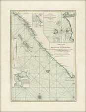
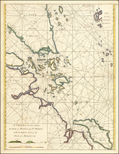
This untitled chart of Banda, Goonog Appee or Burning Mountain, and Banda Neira, published by Laurie & Whittle in London around 1798, provides an intricate representation of the Banda Islands and their naval significance during the late 18th century. Specifically delineating notable locations and topographical details, the map underlines the strategic importance of the Spice Islands, including mentions of anchorage points, gun batteries, and noteworthy geographical landmarks.
The Banda Islands, located in present-day Indonesia, were historically prized for their rich yields of nutmeg, mace, and cloves, making them a hotspot of colonial interest. By the end of the 18th century, European powers vied for control, keen on monopolizing the lucrative spice trade. This map encapsulates the heightened geopolitical tensions of the time, particularly between the British and the Dutch, marking the precise locations of military installations and gun batteries.
The mention of "Battakecka" as a marker for navigation and the reference to "Goonong Appee or Burning Mountain" highlights the volcanic nature of the region, while the details regarding the anchorage points demonstrate the naval accessibility and challenges the islands presented. The note on the rocky point "thrown out of the mountains about 18 years since" hints at the dynamic topography and the role of volcanic activity in reshaping the islands' landscapes.
The significance of the map is further accentuated by its mention of Admiral Rainier, indicating the British naval endeavors in the region. Admiral Peter Rainier's capturing of the Banda Islands from the Dutch in 1796 was a strategic victory, as the map documents the "Total Number of Guns on the different Forts & Batteries when captured" as 252. This detailing not only offers insight into the armed strength of the islands but also into the British naval might and strategy.
Robert Laurie (ca. 1755-1836) and James Whittle (1757-1818) formed their Fleet Street, London-based firm upon the 1794 death of their employer Robert Sayer, himself one of the dominant print and mapmakers of the last half of the 18th century.
Laurie & Whittle started managing Sayer's business as early as 1787. They took over all managerial duties when Sayer's health flagged in 1792, and they changed the imprint in 1794 upon his death. Sayer left the two a 21-year lease on the shop (at £100 a year) and on Sayer's Bolt Court premises, as well as an option to acquire stock and equipment at a preferential price of £5,000 payable over three years.
Robert Laurie retired from the firm in 1812, and his role was assumed by his son, Richard Holmes Laurie (1777-1858). The younger Laurie worked with James Whittle until the latter died in 1818. After R. H. Laurie died in 1858, Alexander George Findlay, FRGS (1812-1875) purchased the firm from his daughters. The firm continues today under another name, specializing in yachting charts.
Laurie & Whittle were prolific print and map publishers, and throughout their careers, they produced numerous very important and rare works. They carried on Robert Sayer's atlas business and were responsible for editions of The Complete East-India Pilot and The American Atlas.