|
||

|

|
|

|
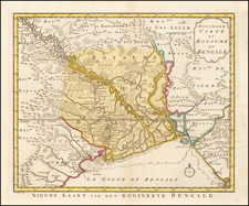
A Chart of the Northern Part of the Bay of Bengal is a significant Indian chart document borne out of the collaboration of several notable marine surveyors: Bartholomew Plaisted, John Ritchie, Captain George Farmer, Captain Augustus Savage, and Benjamin Lacam. Further enriching this work are the nautical observations contributed by Captain John Hicks. The chart, published by Laurie & Whittle on 12th May 1794, maps the area between Point Palmiras and the Arakan shore, focusing on the intricate nautical topography of this part of the Bay of Bengal.
The chart displays an array of significant geographical and tidal information. Key indicators like the timing of high tide, the direction of the strongest flood tides, and the depth of the bay at low tide are all meticulously plotted. This data, along with precise descriptions of the seabed - the sands being hard ground, the channels as soft ground, and the delineation of the Hoogly River and Lacam's Channel as soft blue ground - combine to form a detailed nautical chart vital for navigation and maritime operations of the era.
The chart presents a wealth of astronomic observations, providing latitudinal and longitudinal readings for several significant locations, such as Chandernagor, Calcutta, Mud Point, Light-house Point, and Point Palmiras. These readings, gathered from a range of observers including the Honorable Thomas Howe, the Rev. M. Smith, M. Magee, and Captain John Ritchie, represent an impressive compilation of astronomic knowledge of the period.
This wealth of geographic information is coupled with significant details about the coastal topography. Coastal profiles of notable locations like the Jagernaut Pagoda and the Black Pagoda are carefully delineated. The chart indicates the observable land characteristics when viewed from specific bearings and distances, noting, for instance, the reddish sand characteristic of the shore near these landmarks. These descriptions would have been of significant value to mariners navigating these coasts.
The chart is not only an extraordinary instance of collaboration among several of the era's most renowned marine surveyors but also a testament to the precision and detailed nature of nautical surveying during the late 18th century. It encapsulates the advanced scientific methodologies used in its creation, from astronomical observations to meticulous hydrographic surveying.
As a tool, the chart is a reflection of the naval interests and maritime expansion of the British East India Company and British colonial administration in the late 18th century. The chart's dedication to the Right Honorable Commissioners for the Control of the British Affairs in the East Indies indicates its official endorsement and the significant role it played in the administrative and commercial activities of the British in the region.
In a broader historical context, the chart represents the meeting of scientific observation, commercial interests, and colonial expansion. The thorough detailing of the northern part of the Bay of Bengal underlines the significance of this region for the East India Company and the British Empire at large. The chart is thus a direct reflection of Britain's growing control over the Indian subcontinent during this period.
Robert Laurie (ca. 1755-1836) and James Whittle (1757-1818) formed their Fleet Street, London-based firm upon the 1794 death of their employer Robert Sayer, himself one of the dominant print and mapmakers of the last half of the 18th century.
Laurie & Whittle started managing Sayer's business as early as 1787. They took over all managerial duties when Sayer's health flagged in 1792, and they changed the imprint in 1794 upon his death. Sayer left the two a 21-year lease on the shop (at £100 a year) and on Sayer's Bolt Court premises, as well as an option to acquire stock and equipment at a preferential price of £5,000 payable over three years.
Robert Laurie retired from the firm in 1812, and his role was assumed by his son, Richard Holmes Laurie (1777-1858). The younger Laurie worked with James Whittle until the latter died in 1818. After R. H. Laurie died in 1858, Alexander George Findlay, FRGS (1812-1875) purchased the firm from his daughters. The firm continues today under another name, specializing in yachting charts.
Laurie & Whittle were prolific print and map publishers, and throughout their careers, they produced numerous very important and rare works. They carried on Robert Sayer's atlas business and were responsible for editions of The Complete East-India Pilot and The American Atlas.
![West Bengal Tourist Map [on verso:] Guide Map of Calcutta](https://storage.googleapis.com/raremaps/img/small/97639.jpg)
![Tabula Asiae XI [India and Southeast Asia]](https://storage.googleapis.com/raremaps/img/small/94323.jpg)