|
||

|

|
|

|
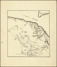
Depicting a pivotal naval engagement from the early days of the American Revolutionary War, "A Plan of the Attack of Fort Sulivan" captures the historic encounter between the British forces led by Sir Peter Parker and the Continental Army stationed at Fort Sulivan on June 28, 1776.
Situated at a strategic point at the mouth of the Ashley River in South Carolina, the significance of Fort Sulivan was immediately apparent to both sides of the conflict. The fort represented a vital stronghold in the southern colonies, providing a line of defense against the encroaching British forces. By highlighting the fort's engagement with the British Squadron, the map serves as a snapshot of the tension and urgency of the war's early days, while the extensive text describing the battle provides a vivid narrative of this strategic confrontation.
The map details not only the positioning of the opposing forces but also the topography of the battleground, with an emphasis on the geographical relationship between the fort and the attacking British ships, all of which are named and illustrated. The measured distance of 900 yards between Bristol and the fort offers an acute sense of the immediacy and intensity of the engagement.
Published for R. Saver and J. Bennett, esteemed purveyors of maps and prints, this piece is a fantastic artifact of the Revolutionary War in the American South. Its documentation of the disposition of the "Provincial Army" on Sulivan's Island and the mainland, as well as British Forces under General Clinton, situated on Long Island, paints a comprehensive picture of the scene on that fateful June day.
This map serves as both a testament to the fraught contest for control over key territory during the American Revolutionary War and a detailed visual record of the historical and tactical context of the Battle of Fort Sulivan. It affords an intimate glimpse into the early days of a conflict that would shape the destiny of a nation.
Rarity
Sayer and Bennett's plan of the Battle of Fort Sulivan is far rarer than William Faden's, which trades in the antiquarian market on almost a yearly basis. The last example of the Sayer and Bennett plan recorded in RBH was sold in 1982.
Transcription of Text Below the Map
The following description of the attack on Fort Sullivan was received in a letter from Sir Peter Parker to Mr. Stephens, Secretary of the Admiralty.
Within Charleston Bar, July 9th, 1776.
It having been judged advisable to make an attempt upon Charleston in South Carolina, the fleet sailed from Cape Fear on the 1st of June, and on the 4th anchored off Charleston Bar. On the 5th, they sounded the Bar and laid down buoys in preparation for entering the harbor. On the 7th, all the frigates and most of the transports crossed the Bar into the five-fathom hole. On the 9th, General Clinton landed on Long Island with about four or five hundred men. On the 10th, the Bristol crossed the Bar with some difficulty. On the 15th, I gave the captains of the squadron my plan for the attack on Sullivan's Island batteries, and the next day I informed General Clinton that the ships were ready. The General chose the 23rd for our joint attack, but unfavorable winds prevented it. On the 25th, the Experiment arrived and the next day crossed the Bar, leading to a new arrangement for the attack. On the 28th, I signaled to General Clinton that I would proceed with the attack. At around 10:30 a.m., I gave the signal to weigh anchor, and about 11:15 a.m., the Bristol, Experiment, Active, and Solebay took position against the fort. The Thunder Bomb, covered by the Friendship armed vessel, aimed at the eastern bastion, and Colonel James provided assistance with shellfire. The Sphynx, Acteon, and Syren were supposed to be positioned to the west to prevent fire ships or other vessels from harassing the engaged ships, to fire upon the works, and if the rebels were driven out, to cut off their retreat. However, this service was not performed due to the pilot's error, causing the three frigates to run aground. The Sphynx and Syren got off in a few hours, but the Acteon remained stuck until the next morning when the captain and officers scuttled and set her on fire. I ordered a court-martial for the captain, officers, and company, and they were acquitted. Captain Hope made his armed ship as useful as possible on the occasion and deserves commendation. During the approximately ten-hour engagement, the ships maintained a brisk fire, causing the rebels to diminish their own fire after about two hours. We forced large parties out of the fort multiple times, but they were replaced by others from the mainland. Around 3:30 p.m., a significant reinforcement from Mount Pleasant hanged a man on a tree behind the fort, and shortly after, the same party seemingly fled, resulting in the fort being silenced and evacuated for about an hour and a half. However, realizing that our army couldn't seize control, a considerable number of people reentered the fort around 6 p.m. and resumed firing from a few guns, as the rest were likely disabled. By 9 p.m., in the darkness, with depleted ammunition, fatigued troops, the ebb tide nearly finished, no perspective from the east, and no possibility of providing further assistance, I ordered the ships to return to their previous positions. From this account, it's clear that if the troops had been able to cooperate, His Majesty would have gained possession of Sullivan's Island. However, I must emphasize that this in no way reflects poorly on our army. Once I saw that the troops hadn't established a foothold on the north end of Sullivan's Island after several hours, I was convinced that landing was impossible and that attempting it would result in the needless loss of many brave men without any chance of success. I am certain this will become evident when General Clinton describes his situation. The Bristol suffered 40 killed and 71 wounded; the Experiment, 23 killed and 56 wounded, with extensive damage to their hulls, masts, and rigging; the Active lost Lieutenant Pike and had 6 men wounded; and the Solebay had 3 men wounded. No one stationed on the Bristol's quarterdeck at the beginning of the action escaped injury. Captain Morris lost his right arm and sustained other wounds, ultimately succumbing to them. The master was wounded in his right arm but will recover its use. I received several contusions at different times, but they are not in any critical areas, so they are not worth mentioning. Lieutenants Caulfield, Molloy, and Nugent served on the Bristol during the action and performed exceptionally well, making it impossible to determine who deserves the most credit. The same can be said of all the petty officers, the ship's company, and the volunteers. I must acknowledge Lord William Campbell, who led the volunteers and accepted the responsibility of directing some guns on the lower gun deck. His lordship suffered a contusion on his left side, but I am pleased to inform you that it is not serious. Captain Scott of the Experiment lost his left arm and sustained other severe wounds, and I fear he will not recover. I cannot conclude this letter without noting that when it was known that we had many men too weak to participate in the action, nearly all the sailors from the transports eagerly volunteered to serve, displaying a truly British spirit and a deep understanding of the cause we are fighting for. I accepted over fifty of them to replace our sick. Many masters of the transports attended with their boats, but special thanks are due to Mr. Chambers, the Master of the Mercury.
All the regiments will be embarked in a few days. The first brigade, consisting of four regiments, will sail for New York in a day or two under convoy, and I hope the Bristol and Experiment will soon follow with the rest.
Sir Peter Parker's squadron consisted of the following ships and vessels:
Ships, etc. Guns Commanders
Bristol - - - - - 50 Sir Peter Parker.
Capt. John Morris.
Experiment - - - - 50 Alexander Scott.
Active - - - - - - 28 William Williams.
Solebay - - - - - 28 Thomas Symonds.
Actaeon - - - - - 28 Christopher Atkins.
Syren - - - - - 28 Tobias Furneaux
Sphynx - - - - - 20 Anthony Hunt
Friendship armed vessel 22 Charles Hope
Ranger Sloop - - 8 Roger Wills
Thunder Bomb - - 8 James Reid
St. Lawrence Schooner Lt. John Graves
Whitehall, August 24.
According to Lieutenant-General Clinton's letter to Lord George Germain dated July 8, 1776, from the camp on Long Island, South Carolina, Sir Peter Parker and the General decided to attempt the reduction of the rebels' fortress on Sullivan's Island, which controlled the key to Charleston Harbor. In order to allow the army to cooperate with the fleet, the General landed his troops on Long Island, which was believed to be connected to Sullivan's Island by a ford passable at low tide. However, to his great disappointment, he found that the channel, which was reported to be eighteen inches deep at low tide, was actually seven feet deep, making it impossible for the army to provide the support they intended.
Robert Sayer (ca. 1724-1794) was a prominent London map publisher. Robert’s father was a lawyer, but his older brother married Mary Overton, the widow of prominent mapmaker Philip Overton and the proprietor of his shop after his death. Mary continued the business for roughly a year after her marriage and then, in early 1748, it passed to Robert. Robert became a freeman of the Stationers’ Company later that year; his first advertisement as an independent publisher was released in December.
Sayer benefited from Overton’s considerable stock, which included the plates of John Senex. In the 1750s, Sayer specialized in design books and topographical prints, as well as comic mezzotints. In 1753, he, along with John Roque, published a new edition of Thomas Read’s Small British Atlas, the first of several county atlases that Sayer would publish.
Sayer’s business continued to grow. In 1760 he moved further down Fleet Street to larger premises at 53 Fleet Street. In 1766, he acquired Thomas Jefferys’ stock when the latter went bankrupt. In 1774, he entered into a partnership with John Bennett, his former apprentice. The pair specialized in American atlases, based on the work of Jefferys. They also began publishing navigational charts in the 1780s and quickly became the largest supplier of British charts in the trade.
Bennett’s mental health declined, and the partnership ended in 1784. As Sayer aged, he relied on his employees Robert Laurie and James Whittle, who eventually succeeded him. He spent more and more time at his house in Richmond. In 1794, he died in Bath.
John Bennett (fl. 1760-d. 1787) was a London printer best known for his role in the successful partnership of Sayer & Bennett. In 1760, Bennett became a servant of Robert Sayer (ca. 1724-1794), the prominent print and map seller, and was apprenticed to him in 1765. In 1774, Bennett became a free journeyman and entered into a partnership with Sayer. They issued joint advertisements and publications. In 1777, Bennett owned 1/3 share in the business. The partnership was likely to continue fruitfully, but in 1781 Bennett began to show signs of mental illness. In 1783, he was admitted to an asylum for nine months and, in 1784, Sayer filed papers to dissolve their business partnership. Bennett died in 1787.
![South Carolina [Charleston Inset]](https://storage.googleapis.com/raremaps/img/small/101136.jpg)