|
||

|

|
|

|
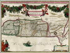
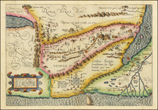
Fine pair of maps of the Holy Land, showing the region in modern times (mid-18th Century) and as known at the time of the 12 Tribes.
The maps are based upon Philippe de La Rue's maps of the region and provide an extensive set of annotations. The map provides and excellent side by side comparison of the place names and places where there were settlements, towns, mountains, rivers, etc., allowing for easy comparison of the region duirng the two periods. These maps, elegantly drawn from the work of the esteemed Philippe de La Rue, are not only visually striking but are also deeply informative due to an array of comprehensive annotations.
"Descriptio Accurata Terrae Promissae Per Sortes XII" is a map that harks back to the ancient past, meticulously detailing the biblical Holy Land as divided among the Twelve Tribes of Israel. Each territory is distinctly marked, demonstrating an impressive accuracy that reveals an in-depth understanding of biblical geography. The map brings to life the ancient topography with its hills, mountains, and rivers, and marks the locations of venerable cities and settlements, sketching out a vivid panorama of the region as it existed in times of antiquity.
In contrast, the map "Terre Sainte Moderne" brings forth a portrayal of the same region, but from a contemporary (18th Century) perspective. It abandons the mythical air of the ancient past to focus on the practical, the physical, and the politically defined. However, it maintains the charm and mystique of the Holy Land with its intricate details. Modern cities, towns, and settlements are marked with accuracy, and physical features like mountains and rivers are accurately drawn, giving a tangible sense of reality to the religious land.
The most extraordinary feature of these maps lies in their simultaneous presentation on a single sheet of paper. This arrangement allows an easy comparison between the Holy Land as it was in the biblical times and as it stands in the modern era. The place names, settlements, geographical features, and significant locations are mirrored on both maps, enabling a fascinating cross-comparison of the region across two vastly different epochs.
The text below the ancient map of the Holy Land translates as follows:
This land was called the Land of Canaan because it was divided among eleven peoples descended from the eleven sons of Canaan. Abraham, who lived in Hebron, and Lot, who lived in Sodom, divided it into eastern and western parts. Jacob kept the paternal portion, and Esau retreated to the south between Mount Seir and the Gold Mountain, which he named Edom. It was then named the Promised Land, due to the promise God made to the Ishmaelites, who conquered it on His order and divided it among their twelve tribes. David and Solomon divided it into seventeen administrations - five beyond the Jordan and twelve on this side. Under Solomon and Rehoboam, it was divided into two parts, forming the Kingdoms of Judah and Israel. Under the great hero of the Romans, it was torn into Tetrarchies and Toparchies. Finally, since the year 100, it has been called the Holy Land, and since that time the Romans, Persians, Emperors of the East, Saracens, Mamluks, Franks, and Bedouin Saracens have successively been its masters. It is now under the domination of the Turks who conquered it from the latter. In the time of J.C., it was divided into Upper Galilee, said to be of the Gentiles, which contained the tribes of Asher and Naphtali, Lower Galilee, which contained those of Zebulon and Issachar, Samaria, which on this side of the Jordan contained those of Manasseh and Ephraim, Judea, where were the lands of Judah, Benjamin, Dan and Simeon, with the Five Cities or Satrapies of the Philistines, the Coast and the River of the Sidonians, and Edom, and beyond the Jordan, six provinces: Iturea, Auranitis, Upper and Lower Gaulanitis, Batanea, Trachonitis, and Peraea or Galaatide, called Decapolis by Pliny.
The text below the ancient map of the Holy Land translates as follows:
The Beglerbey of Damascus, who is superior to the Emirs or Princes and the Sanjaks, always has more than twenty thousand men maintained at the expense of the Turk to force the rebels to pay tribute and obey the Pasha. It is by this that the Grand Seigneur has so far maintained his obedience to peoples of a different religion than his own, who impatiently bear the yoke of his domination. Beyond the Jordan is the state of the greatest Prince of the Arabs, who commands all the Desert, which occupies from the HOLY LAND to the Euphrates an extent of country 30 days long by 12 wide. He acknowledges the Grand Seigneur without being tributary to him, takes the title of King, usually camps under tents, always followed by ten thousand Arab men. When his herds, which are his greatest wealth, and who always accompany him, have eaten the pastures of one country, he goes to another, which sometimes obliges the Pashas of Damascus and Aleppo to give him presents, to guarantee their Governments from the ravage of these Locusts. This King can make a body of cavalry of twenty-five to thirty thousand horses with the help of several Arab chiefs who live on his Lands wherever they please, on condition of paying him a tribute and joining him when he needs them.
The map is quite rare, with no examples recorded by AMPR in dealer catalogues or auction records going back more than 20 years.
Nicholas de Fer (1646-1720) was the son of a map seller, Antoine de Fer, and grew to be one of the most well-known mapmakers in France in the seventeenth century. He was apprenticed at twelve years old to Louis Spirinx, an engraver. When his father died in 1673, Nicholas helped his mother run the business until 1687, when he became the sole proprietor.
His earliest known work is a map of the Canal of Languedoc in 1669, while some of his earliest engravings are in the revised edition of Methode pour Apprendre Facilement la Geographie (1685). In 1697, he published his first world atlas. Perhaps his most famous map is his wall map of America, published in 1698, with its celebrated beaver scene (engraved by Hendrick van Loon, designed by Nicolas Guerard). After his death in 1720, the business passed to his sons-in-law, Guillaume Danet and Jacques-Francois Benard.
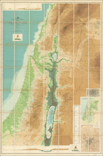
![[ Jordan ] Tourist Map -- The Hashemite Kingdom of Jordan](https://storage.googleapis.com/raremaps/img/small/97635.jpg)