|
||

|

|
|

|
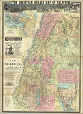
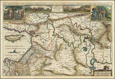
Rare 1717 two-sheet map of the Holy Land stands as an important piece of cartographic history. Derived from an earlier work, it offers both geographical and historical insights into the region it depicts.
Based on the four-sheet map of the Holy Land created by Jacob Bonfrerius in 1631, this rendition showcases a careful condensation of the original. Jacob Bonfrerius, more commonly known by his Latinized name "Jacobus Bonfrerius," was a Jesuit scholar born in 1573 in Belgium. He was renowned for his theological writings, especially his commentaries on the Old Testament. His commitment to his scholarly work is reflected in the precision and detail of his 1631 map, which was published in Amsterdam—a hub for cartographic and maritime activities during that era.
The 1717 map retains much of Bonfrerius’s dedication to accurate detailing. Cities, both major and minor, from Jerusalem to Bethlehem, are marked clearly. Natural features, such as mountains, valleys, and rivers, are also included, providing viewers with a comprehensive understanding of the region's topography.