


|
||

|

|
|

|
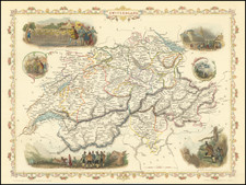
The Earliest Obtainable Modern Map of the area around Lake Constance.
Lacus Constantiensis XX Tab Nova, produced by Sebastian Munster and published in Basel in 1540, represents a pioneering cartographic depiction of the area surrounding Lake Constance. As the earliest obtainable modern map of this region, its importance in the annals of cartographic history is significant, offering a window into the geographical understanding of this European locale in the mid-16th century.
In the 1540s, Europe was in the throes of the Renaissance, a period characterized by rapid advancements in art, science, and knowledge. The spirit of exploration and discovery was pervasive, influencing diverse fields including cartography. The publication of maps such as Lacus Constantiensis XX Tab Nova was emblematic of the time's insatiable thirst for accurate geographical information. The Lake Constance area, encompassing parts of modern-day Germany, Switzerland, and Austria, held strategic and commercial significance, making accurate mapping of this region all the more crucial.
Sebastian Munster, a renowned cosmographer and Hebrew scholar of his time, was at the forefront of this cartographic renaissance. The map's intricacies and attention to detail embody the shift from medieval to modern cartography, where the emphasis increasingly rested on precision and direct observation. Coming from Munster's 1540 Geographia, this map was more than just a representation of topography; it was a testament to the evolving relationship between humans and their understanding of the world around them.
The features delineated in Lacus Constantiensis XX Tab Nova offer invaluable insights into the physical and political landscape of the Lake Constance region during the Renaissance. The various townships, waterways, and natural landmarks suggest an intricate mesh of human activity and natural beauty. The map, in essence, stands as both an artifact of Renaissance scholarship and a beacon illuminating the rich history of the Lake Constance area.
Sebastian Münster (1488-1552) was a cosmographer and professor of Hebrew who taught at Tübingen, Heidelberg, and Basel. He settled in the latter in 1529 and died there, of plague, in 1552. Münster made himself the center of a large network of scholars from whom he obtained geographic descriptions, maps, and directions.
As a young man, Münster joined the Franciscan order, in which he became a priest. He then studied geography at Tübingen, graduating in 1518. He moved to Basel, where he published a Hebrew grammar, one of the first books in Hebrew published in Germany. In 1521 Münster moved again, to Heidelberg, where he continued to publish Hebrew texts and the first German-produced books in Aramaic. After converting to Protestantism in 1529, he took over the chair of Hebrew at Basel, where he published his main Hebrew work, a two-volume Old Testament with a Latin translation.
Münster published his first known map, a map of Germany, in 1525. Three years later, he released a treatise on sundials. In 1540, he published Geographia universalis vetus et nova, an updated edition of Ptolemy’s Geographia. In addition to the Ptolemaic maps, Münster added 21 modern maps. One of Münster’s innovations was to include one map for each continent, a concept that would influence Ortelius and other early atlas makers. The Geographia was reprinted in 1542, 1545, and 1552.
He is best known for his Cosmographia universalis, first published in 1544 and released in at least 35 editions by 1628. It was the first German-language description of the world and contained 471 woodcuts and 26 maps over six volumes. Many of the maps were taken from the Geographia and modified over time. The Cosmographia was widely used in the sixteenth and seventeenth centuries. The text, woodcuts, and maps all influenced geographical thought for generations.
![[ Salzburg Lungau - Tamsweg District -- Road and Trekking Map for Southern Salzburg ]](https://storage.googleapis.com/raremaps/img/small/100458.jpg)