|
||

|

|
|

|
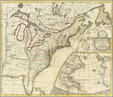
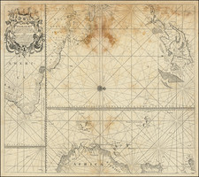
Early English map of the southern part of the British Colonies in America, New France, Louisiana, the Caribbean and Central America.
This is the first map of America engraved by Emanuel Bowen. The detail of the map is quite remarkable and the engraving quite refined. The annotations and detail in the map are also excellent for the period.
The notes at the top right read as follows:
K.Charles I. by Charter dated June 30 1665 granted to Chanc Clarendon D.of Albemarle, &c. the Province of Carolina extending Southward to the 29. Deg: of North fat.which takes in F.S. Augustin now possessed by the Spaniards; In 1729 the British Parliament purchased S. Carolina of the Proprietors for his Majesty K George, who soon after granted to Trustees for establishing ye Colony of Georgia the lands between the Rivers Savanah and Altamaha.
The Spanish Gallions coming before R.de la Hacha notice is sent thither from thence over land to Cartagena, Lima, Panama &c.to hast =en the King's Treasure. They then continue their Course to Cartagena and after a stay of 2 Months go to Puerto Bello and are about a Month taking in the Treasure from Panama &c. then they return to Cartagena finish their Lading & Sail to the Havana to meet the Flota from la Vera Crux, whence they proceed together thro the Gulf of Florida for Old Spain.
Course TO Jamaica. All Ships from Europe or Africa bound for Jamaica make the Island of Antego or some other of Caribbees near it, because from thence they can bear away before the Trade Winds due West to Jamaica. Ships also from Carolina and all our Plantations on the Continent of America are obliged to get to Antego or the E. of S Cristophers, and then fall into the same Trade Wind Course; the Gulph of Florida which seems to be a nearer way for them being impracticable, the Current there setting from S. to N.& after that the Trade Winds being for Leagues against them.
FROM Jamaica by the Gulph of Florida. From the W.Point of Jamaica to the W. End of Cuba Ships have the advantage of the Trade Winds, which are after that till they get into the Gulph as much against them; so that while they are tripping it between Cape Florida and Cuba ,the Guarda Costas from the latter can easily beard own upon them Again, as the Florida Coast is flat and Shoaly for 7 or 8 Leagues out they are obliged to keep near the Bahamas, and are again in danger from thence, all those Islands being Spanish, except Providence, where if our Ships get, and take any Logwood on board, tho' the Growth of that Island, the Spanish Guarda Cofta's which lie off the Abaco I will make Prize of them pretending that food only grows in their Territories.
FROM Jamaica by the Windward Passage. The most difficult part of this Course is from Port Royal to Point Morant which being against ye Trade Winds, has sometimes taken up 6 Weeks, tho' but 20 Leagues. But the most dangerous is from that Point till they are clear of Crooked Island, a Course of 160 Sea for the Spaniards from Cuba, Porto Rico & Hispaniola (and sometimes the French) are in wait to intercept ye English This is called the Windward Passage because Ships are obliged to keep to the Windward to avoid the Shoals on the Coast of Cuba
Emanuel Bowen (1694?-1767) was a British engraver and print seller. He was most well-known for his atlases and county maps. Although he died in poverty, he was widely acknowledged for his expertise and was appointed as mapmaker to both George II of England and Louis XV of France. His business was carried on by his son, Thomas Bowen. He also trained many apprentices, two of whom became prominent mapmakers, Thomas Kitchin and Thomas Jeffreys.
![(Civil War) Fredericksburg … [with] Map… of the Sioux Expedition [with] Map of the Fight of the 14th A.C. Buzzard Roost, GA [and ] Big Mound [and] Dead Buffalo Lake [and] Dry Fort Creek](https://storage.googleapis.com/raremaps/img/small/97072.jpg)