


|
||

|

|
|

|
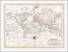
Previously Unknown World Map -- Second Separately Published World Map Published in the United States
Previously unknown map of the World, published by William Norman in Boston.
The map shows the tracks of Captain James Cook's Discoveries from his 3 voyages, including his discovery of Hawaii. The discoveries of Vancouver and La Perouse are not shown and the latest date on the map is 1779.T. he map names the United States, but does not show any of Kentucky (established in 1792) or Tennessee (established in 1796).
The map is undated but bears the imprint of William Norman, Bookseller and Stationer. Norman was the successor to the business of his father, John Norman. The earliest maps to appear with William Norman's name on them begin to appear in about 1791, but these seem to be later states of maps first issued by his father. The earliest maps which seem to be his work begin to appear in about 1794. On April 4, 1806, William Norman advertised his intention to publish a world map in the New-England Palladium:
Books, Charts and Maps. PUBLISHED and sold by WM. NORMAN, Pleasant-Street, Boston; sold likewise by WM. PELHAM, No. 59, Cornhill; and by all the principal Booksellers in the United States,
MAPS.
Maps of Massachusetts, Compiled from Actual Surveys. made by order of the General Court, by OSGOOD CARLETON, Esq. in two Parts, including the Province of Maine, very large ---price 3 dolls. colored. . . price 1 dol. colored.
Map of N. Hampshire --- price 75 cents, colored. . . .
Map of the World --- price 75 cents, colored.
Plan of the Town of Boston, from the best Authorities, with the new division of the Wards, and all the latest improvements, additions and corrections. This Plan will be published in a few days.
We believe this is the second earliest separately published World map to be published in the United States, after the Ruggles map, which is known in a single copy.
The map may related to a world map published by Thomas Brown in Edinburgh. In dealer catalog entries in 1987 and 1991, Kit Kapp described a slightly smaller world map on Mercator's projection by Thomas Brown which he dated to circa 1792 on a Mercator Project. Thomas Brown created an atlas map in about 1801 with the same title, but the atlas size suggests that it was quite a bit smaller.
We have also identified a single example of an undated map, lacking a publisher's imprint, which appears to be a later state of the map. We also note the existence of two hand drawn school maps dated 1814 and drawn at the Washington Academy, which have very similar titles and are likely copied from Norman's map.
Rarity
The present example of Norman's map is apparently the only extant example.
We find no record of the map in OCLC or general internet searches. Ashley Baynton-Williams had not previously recorded the map in his research.
![[English Edition!] Nova Totius Terrarum Orbis Geographica Ac Hydrographica Tabula Auct. Henr: Hondio. . . . 1630](https://storage.googleapis.com/raremaps/img/small/78002.jpg)

![[World -- Terrestrial Globe Gores]](https://storage.googleapis.com/raremaps/img/small/89195.jpg)