|
||

|

|
|

|
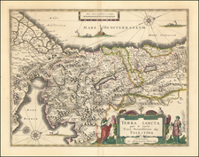
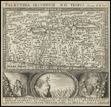
Rare mid-19th Century map of the Holy Land, showing the region during the Roman era. This title, when translated, means "Map of Palestine Under the Dominion of the Romans."
Regional Distinctions
The map employs varying colors to differentiate between regions, providing a clear depiction of the territories during the said period:
-
Phoenice: This represents the area inhabited by the ancient Phoenicians.
-
Galilaea: Presently known as Galilee, it has a rich history referenced in the New Testament.
-
Samaria: Previously a distinct kingdom from Judea, its unique culture and history are showcased separately.
-
Arabia Consula: This delineates the territories towards the south, integrating them into the broader Arabian landscape.
-
Judaea: A central region for Jewish culture and history, it's presented as a significant territory.
Craftsmanship and Origin
The accompanying note indicates the techniques used in crafting this map, pointing to either a paintbrush or stone lithography. Moreover, it identifies the map as a part of a geographic atlas produced in Naples by Benedetto Marzolla.
![[Holy Land]](https://storage.googleapis.com/raremaps/img/small/81990.jpg)