


|
||

|

|
|

|
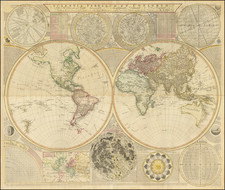
Samuel Dunn's A General Map of the World. Or Terraqueous Globe with all the New Discoveries and Marginal Delineations, Containing the Most Interesting Particulars in the Solar, Starry and Mundane System is a panoply of cartography and scientific knowledge from the late 18th century. Published by Laurie & Whittle in London on May 12, 1794, this map provides not only geographical information but also encapsulates the contemporary understanding of astronomy and celestial navigation, creating a dense and multifaceted piece.
The main feature of the map comprises two hemispheres, one titled "Western Hemisphere or the New World by Mr. D'Anville. With the New Discoveries and Several Additions," and the other "Eastern Hemisphere or the Old World by Mr. D'Anville. With the New Discoveries and Several Additions." The duality of the "New World" and the "Old World" emphasizes the period's expanding global awareness and exploration, underscored by new discoveries and additions.
Furthermore, the map traces the voyages of renowned explorers like Captain Cook, St. Allouarn, Bouvet, Bougainville, and Anson. These tracks underscore the importance of maritime exploration and colonial expeditions during this time, forming the basis of new geographical knowledge.
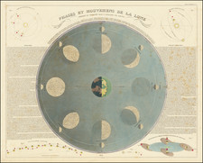
In addition to earthly landscapes, Dunn’s map is imbued with contemporary celestial knowledge. The upper left corner contains engraved depictions of the solar system and close-up representations of the Sun, Saturn, and Mercury as seen through a telescope. Celestial maps of the northern and southern hemispheres sit at the map's center, indicating a thorough blending of terrestrial and celestial geography.
Below the world map, Dunn includes a "Selenography or A Map of the Moon, according to Father Riccioli." He raises the debated question of whether the moon has an atmosphere and is inhabited, illustrating the active scientific discussions of the period.
Additional diagrams explain the changing of the seasons, celestial bodies like Mars and Jupiter, and intricate measurement scales. One striking feature is the "Analemma," a graphical representation depicting the Sun's position in the sky at a certain time of the day over a year's course, used for sun path diagrams and as a time correction in sundials.
The map is a testament to the era's intellectual curiosity and burgeoning scientific knowledge. It brings together geographic exploration, celestial observations, and scientific discourses, making it more than a simple map - it is a snapshot of the understanding of the world in the late 18th century.
Samuel Dunn (bap. 1723-1794) was a teacher of mathematics and navigation who published, among other things, maps and charts. Although information about his early education is lacking, by age nineteen he was leading his own school and teaching writing, accounting, navigation, and mathematics in Devon. In 1751, he moved to London, where he taught in several schools and tutored privately.
By the 1760s, Dunn was known as a respected astronomer and had published a range of textbooks on math, navigation, and astronomy. After the publication of the Nautical Almanac, Dunn acted as a certifier of ships’ masters under the new system, on behalf of the Board of Longitude. He performed similar work for the East India Company, as well as made charts of the East Indies. In 1776 he published A New Variation Atlas and, in 1777, A New Epitome of Practical Navigation, or, Guide to the Indian Seas. By 1780, he was named editor of the New Directory for the East Indies, which included his own charts. In 1786, he released a pioneering study, Theory and Practice of Longitude at Sea. He also designed several instruments for navigation.
Dunn died at his home in Fleet Street in January 1794. His books and maps were auctioned at Sothebys in a sale of over 1,000 lots. Many of these were bought by Alexander Dalrymple, hydrographer of the East India Company and soon-to-be-named first head of the Hydrography Office.
![Columba [Dove]](https://storage.googleapis.com/raremaps/img/small/76778.jpg)
![[Synopsis Coeli Superioris] and [Synopsis Coeli Inferioris Austrina]](https://storage.googleapis.com/raremaps/img/small/83287.jpg)
![[ Eastern Hemisphere Globe Gores. ] (Nova et integra universi Orbis descriptio)](https://storage.googleapis.com/raremaps/img/small/54480.jpg)
![[Eastern Hemisphere] Le Globe Terrestre Represente En Deux Plans-Hemispheres . . . 1740](https://storage.googleapis.com/raremaps/img/small/92751.jpg)