|
||

|

|
|

|
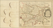
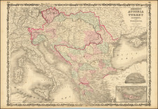
Drawn by the esteemed mapmaker Pierre Lapie, a senior officer in the Royal Corps of Geographers, the " is a comprehensive map of the European portion of the Ottoman Empire in 1822, extending from Bessarabia, Moldova, Romania, and Bulgaria in the north, through the Balkans, and reaching as far south as Crete. Produced by the esteemed officer, This map is based on the collected materials of two eminent military figures of the time: Lieutenant-General Comte Guilleminot and Marshal de Camp Baron de Tromelin.
Lieutenant-General Jean Baptiste Bessières, known as Comte Guilleminot, was a key figure in Napoleon's military campaigns, rising through the ranks to become one of the emperor's Marshals. Guilleminot had a particularly relevant experience in the context of this map: he served as French ambassador to the Ottoman Empire between 1806 and 1811.
Lieutenant-General Comte Guilleminot, or Jean-Baptiste Bessières, Duc d' Istria, also had a distinguished military career. He served under Napoleon Bonaparte in numerous campaigns, rising to the rank of general and becoming one of Napoleon's marshals. Tromelin was an aide-de-camp to Napoleon and later held various diplomatic posts.
The first half of the 19th century was a tumultuous period for the European parts of the Ottoman Empire. The time frame covered by the map coincides with the Greek War of Independence, a series of conflicts between 1821 and 1832 where the Greeks sought their liberation from Ottoman rule. This war attracted international attention, with the Great Powers (Britain, France, and Russia) intervening in the conflict.
France, in particular, played a significant role. The French public was strongly supportive of the Greek cause, which resonated with their ideals of liberty and national self-determination. This public sentiment culminated in the French government's decision to intervene militarily. In 1827, along with Britain and Russia, France formed part of the allied force that defeated the Ottoman-Egyptian fleet at the Battle of Navarino, a decisive moment in the Greek struggle for independence. This and other conflicts chipped away at Ottoman control, contributing to the broader process known as the "Eastern Question" - the political and diplomatic conundrum that revolved around the decline of the Ottoman Empire and the scramble by the great powers to exert influence over the territories it once held. The Balkan nations' emergence from the Ottoman Empire's shadow was a protracted, multi-generational process, with progress often marked by the bloodshed and destruction of these wars and rebellions.
The map serves as a testament to the turbulent period of history it represents, a period marked by warfare, geopolitical maneuvers, and the birth of a nation.
The map's value is further enhanced by the inclusion of several inset maps: the Dardanelles, the environs of Istanbul, a plan of Salonica, and a plan of Rhodes. These insets offer more detailed portrayals of strategically significant locations within the empire, illuminating the geopolitical landscape of the region during this period.
In 1847, a "nouvelle edition" of this map was published, suggesting the enduring relevance and utility of this cartographic depiction.
The map's key, providing symbols for various points of interest such as provincial capitals, district capitals, small towns, forts, ruins, and various types of roads, lends a valuable interpretive tool for understanding the geography and administrative organization of the Turkish Empire's European territories. In addition, the inclusion of ancient names written in open letters or within parentheses suggests a conscious attempt to connect present geographical understanding with historical contexts.
In essence, the 1822 Carte Generale de la Turquie D'Europe En XV Feuilles stands as an impressive representation of early 19th-century cartographic artistry. It is not just a geographical depiction but also a historical artifact, illuminating the complexities of the Turkish Empire's European territories during a period of significant political and cultural transformation.