


|
||

|

|
|

|
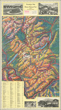
Davos: Parsenn Strela Brämabüel/Jakobshorn, a remarkable map produced around 1965, offers striking bird's-eye views of two famed ski slopes in Davos, a renowned resort town in Grisons, Switzerland. Expertly illustrated by Hausmann, it showcases the pristine allure and dramatic elevations of Davos, ranging from 5,118 to 9,286 feet, presenting a captivating tableau of the region's alpine grandeur.
The mid-1960s marked a period of global fascination with winter sports, with Davos emerging as one of the premier destinations in Europe for skiing and winter recreation. Nestled in the Swiss Alps, the town's rich history and sporting legacy were further highlighted by such well rendered maps. The dual perspectives of Parsenn Strela and Jakobshorn slopes, as captured in this map, convey the vastness and topography of Davos, inviting viewers to trace the routes and contemplate the serene beauty of these snow-capped terrains.
Hausmann's distinctive design skills are evident throughout the map, with each slope's characteristics represented. The collaborative effort that went into this work, featuring contributions from various photographers and designers, speaks volumes about the dedication and artistry that went into its creation. Photographs by Furter, Gehri, Holliger, Kunert, Meerkämper, Reiss, and Schellenberg-Gensetter, as well as text by Dürst, enrich the map's content, providing multifaceted insights into the region's splendor.
While the map itself stands as a testament to Davos' significance in winter sports history, it also offers a glimpse into the collaborative cartographic and photographic traditions of mid-20th-century Switzerland. Printed by Buchdruckerei Davos AG, and with a cover by Glaser, it exemplifies the synthesis of art and information that defined the period, capturing the essence of a winter wonderland that continues to captivate global audiences.
![[Uncut promotional broadsides for ] Map of the Surface-Feeding Ducks, Swans and Geese of North America](https://storage.googleapis.com/raremaps/img/small/92052.jpg)