|
||

|

|
|

|
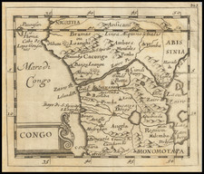
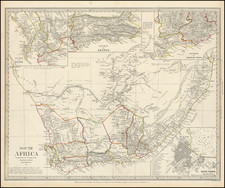
Herman Moll's 1728 map of Southern Africa and Madagascar is a finely crafted work, providing insights into the 18th-century view of the region.
Detailed areas on the map include Congo, Angola, Macao, Zanguebar (modern Zanzibar), Monemugi, Benguela, Mataman, Sofala, Sabia, Monomotapa, and Caffers.
Congo and Angola, located on the western coast of Africa, have rich histories dating back centuries. The Kingdom of Kongo was one of the most powerful states in sub-Saharan Africa until Portuguese contact in the late 15th century. Angola was also home to powerful kingdoms like Ndongo and Kongo, which eventually fell under Portuguese control.
Macao, possibly referring to the Makua people, a Bantu ethnic group primarily in northern Mozambique, gives insight into the diverse ethnic composition of the region. Zanguebar, or Zanzibar, is an island off the eastern coast of Africa with a history of trade with the Middle East, India, and China dating back at least a millennium, although here it also references modern day Tanzania.
Monemugi represents an indigenous ethnic group in the region, showcasing Africa's rich diversity. Benguela is a city in present-day Angola and was an important part of the Portuguese colonial empire. Mataman is possibly a reference to the Matamba Kingdom, a pre-colonial African state located in present-day Angola.
Sofala, now part of Mozambique, was once the focal point of gold trade along the Swahili coast. Sabia may refer to a region in present-day Zimbabwe, while Monomotapa represents the historic Mutapa Empire, a significant African kingdom in the region from the 15th to the 17th centuries.
Lastly, Caffers is an outdated term used by Europeans to refer to the Khoikhoi and San people, indigenous groups of Southern Africa. The presence of these names on Moll's map underlines the complex and diverse socio-cultural dynamics of Southern Africa during this era.
In the heart of the map, two features appear as lakes, Zaire Morais and Zaflan Morais. These are possibly references to an ancient belief in the existence of two lakes feeding the Nile.
In all, Moll's 1728 map offers a captivating glimpse into the geographical understanding of Southern Africa in the early 18th century.
Herman Moll (c. 1654-1732) was one of the most important London mapmakers in the first half of the eighteenth century. Moll was probably born in Bremen, Germany, around 1654. He moved to London to escape the Scanian Wars. His earliest work was as an engraver for Moses Pitt on the production of the English Atlas, a failed work which landed Pitt in debtor's prison. Moll also engraved for Sir Jonas Moore, Grenville Collins, John Adair, and the Seller & Price firm. He published his first original maps in the early 1680s and had set up his own shop by the 1690s.
Moll's work quickly helped him become a member of a group which congregated at Jonathan's Coffee House at Number 20 Exchange Alley, Cornhill, where speculators met to trade stock. Moll's circle included the scientist Robert Hooke, the archaeologist William Stuckley, the authors Jonathan Swift and Daniel Defoe, and the intellectually-gifted pirates William Dampier, Woodes Rogers and William Hacke. From these contacts, Moll gained a great deal of privileged information that was included in his maps.
Over the course of his career, he published dozens of geographies, atlases, and histories, not to mention numerous sheet maps. His most famous works are Atlas Geographus, a monthly magazine that ran from 1708 to 1717, and The World Described (1715-54). He also frequently made maps for books, including those of Dampier’s publications and Swift’s Gulliver’s Travels. Moll died in 1732. It is likely that his plates passed to another contemporary, Thomas Bowles, after this death.
![[Southern Africa] Tabula nova partis Africae](https://storage.googleapis.com/raremaps/img/small/103295.jpg)