|
||

|

|
|

|
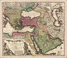
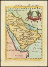
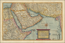
Turquie d'Asie Arabie, Perse, Caboul, Beloutchistan et Turkestan, published circa 1837 by C.V. Monin in Paris, is an intricate steel-engraved map offering an in-depth geographical overview of Western and Central Asia during the early 19th century. This map stands as an embodiment of meticulous French cartographic practice and a valuable historical record of a region in flux.
This map encompasses vast territories, spanning from modern-day Turkey to Central Asia, including regions such as Persia (Iran), Arabia, Kabul (Afghanistan), Beluchistan (Balochistan), and Turkestan. The geographical detail in this map offers a window into the understanding of these areas during the early 19th century, a period characterized by geopolitical shifts and the burgeoning impact of European colonialism.
The map was created by some of the most skilled craftsmen of the time: engraved on steel by L. Grenier, printed by Mangeon, and inscribed by Bénard, reflecting the complex process and collaborative nature of map-making in this era. The medium of steel engraving, a relatively new technology in the early 19th century, allowed for higher precision and a greater level of detail, resulting in maps of superior quality.
Finally, the publisher, C.V. Monin, was based at Rue Taranne, 14, in Paris—a vibrant hub of intellectual and cultural activity during the period. This specific provenance further enhances the cultural and historical significance of this map, encapsulating the period's keen interest in exploration and understanding foreign territories.