|
||

|

|
|

|
Jean Migeon's map, titled "Turquie d'Asie et Perse", provides a fascinating look at Turkey in Asia, and Persia as they stood in the second half of the 19th century. Published in Paris around 1870, the map is a testimony to the geopolitical structure and economic interconnections of the region at that time.
The map delineates major cities, rivers, deserts, and trade routes of the region. The use of different colors to mark subregions helps to highlight the territorial divisions within the region. Migeon's attention to detail and precision enhances the map's usability and aesthetic appeal, making it a practical tool for navigation and a decorative piece of cartographic art.
One of the notable features of the map is a large vignette of "Damas," or Damascus, the capital of modern-day Syria. The illustration shows two minarets and a large domed mosque, offering a glimpse into the city's Islamic architectural influence. This detailed vignette serves as a symbol of the vibrant culture and historical significance of Damascus.
During this period, the Ottoman Empire was undergoing significant changes. Often referred to as the "Eastern Question" in European diplomatic circles, the slow decline of the once-mighty Ottoman Empire was a concern for European powers. The Empire embarked on a series of reforms known as Tanzimat, aiming to modernize the empire along European lines and prevent its disintegration.
Meanwhile, Persia, under the Qajar dynasty, was experiencing a period of rapid modernization known as the "Persian Constitutional Revolution." This period saw the establishment of a parliament, a written constitution, and a move toward secularization. Despite these strides towards modernity, Persia was grappling with internal instability and external pressure from both the Russian and British empires.
In the northern part of the Arabian Peninsula, in the second part of the 19th century, the Emirates, including Dubai, Abu Dhabi, and Qatar, were largely autonomous tribal societies, though they were nominally under the control of the Ottoman Empire. These regions were sparsely populated and largely sustained by pearl diving, fishing, and local trade. The establishment of British protectorates in the late 19th and early 20th centuries would eventually lead to the formation of the United Arab Emirates in 1971.
The late 19th century was a time of significant transformation for the trade routes crisscrossing the Arabian Peninsula, Asia Minor, and the Persian Empire. Migeon's "Turquie d'Asie et Perse" offers a snapshot of these crucial arteries of commerce.
Trade routes during this period were impacted by a combination of factors including advancements in transportation technology, changing political landscapes, and shifting economic priorities. These elements, along with the region's historical significance as a hub of east-west trade, shaped the commercial landscape captured in Migeon's map.
Across the Arabian Peninsula, traditional land-based trade routes were evolving. The advent of steamships and the opening of the Suez Canal in 1869 brought a shift from overland to maritime routes. This caused a decline in the importance of some historical caravan routes, while ports along the Red Sea and Persian Gulf gained significance.
The cities of Mecca and Medina, while primarily religious centers, also served as important commercial nodes due to the annual influx of Muslim pilgrims for Hajj. Similarly, coastal cities like Dubai and Abu Dhabi became more crucial due to pearl trade and their increasing role as transit points for goods moving between Asia and Europe.
In Asia Minor, the part of the Ottoman Empire that corresponds to modern-day Turkey, the traditional Silk Road trade routes had long been in decline. However, the region still retained its strategic importance due to its geographical location at the crossroads of Europe and Asia. The cities of Istanbul and Izmir served as key trading hubs, connecting the vast hinterland of the Ottoman Empire to European markets.
The Persian Empire, or modern-day Iran, was a critical junction between the East and West. Despite the decline of the Silk Road, Persia maintained a network of caravan routes facilitating trade across its rugged terrain. Cities like Tehran, Isfahan, and Tabriz were essential centers of commerce, dealing in goods like silk, carpets, spices, and precious metals. Persia's importance was further amplified by the discovery of oil towards the end of the 19th century, although its impact on trade wouldn't be fully realized until the 20th century.

![[ Asia Minor ] Tabu. Nova Asiae Mi.](https://storage.googleapis.com/raremaps/img/small/103196.jpg)
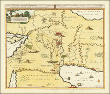
![Carte de la Turquie, de l'Arabie et de la Perse, dressée sur les mémoires les plus récents rectifiée par les observations de Messieurs de l'Académie Royale des Sciences par G. de L'Isle, géographe. [Map of Turkey, Arabia, and Persia, drawn up based on the most recent memoirs and corrected by the observations of the gentlemen of the Royal Academy of Sciences by G. de L'Isle, geographer.]](https://storage.googleapis.com/raremaps/img/small/94075.jpg)