|
||

|

|
|

|
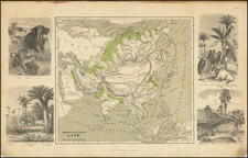
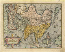
Striking example of the 1766 edition of Guillaume Danet.
The map d is a rich tapestry of scientific observations combined with period artistry.
The map is surrounded by a collection of colorful coats of arms, each representing a different Asian state or country. This extensive use of heraldic emblems underlines the intricate political landscape of the era. The viewer's gaze is then guided towards the heart of the map, where a decorative cartouche captures attention. Mercury, the Roman god of travelers, points towards the French coat of arms, potentially symbolizing the aspirations of French explorers during this period. Asia is personified as a robed woman, holding a scepter topped by a crescent moon, an allegory of the continent's exoticism. An elephant's head and a camel enrich the tableau, embodying the diverse fauna native to Asia.
Of geographical interest is the Sea of Korea, or Mer de Coree, given its contemporary nomenclature disputes. The map also highlights regions like Compagnie Land and Yesso, territories considered partially known or even mythical during the 18th century.
Moving to the northeastern region, a cryptic note suggests an intriguing relationship between the indigenous island inhabitants and the Russian Empire: "Les Habitans de cette Isle payent contribution aux Moscovites en Peltereries." This relationship, however, remains as elusive as the true identity of this island, adding a layer of mystery to the map.
Notably, west of this island, the map introduces an area identified as Tzchalatski, with inhabitants described as "alliez des Tzukischi et aussi feroces." These names, potentially referring to indigenous groups of northeast Asia, provide insights into the perceived social and political dynamics of the time. The Tzchalatski, described as allies and equally as fierce as the Tzukischi, hint at regional alliances or shared cultural traits. Immediately to the south, the Tzukischi are described as a warrior-like nation with a striking note: when taken as prisoners, they supposedly kill themselves. While this depiction provides a glimpse of these groups' character as perceived by the map creators, it likely reflects more the biases and cultural disconnect of the period rather than the complex realities of these groups.
In its entirety, this antique map serves as a window into an 18th-century worldview, merging political, cultural, and natural features into a unified narrative. Beyond its geographical delineations, it weaves a captivating story of exploration, discovery, and the attempt to comprehend the world's richness, standing as a testament to the human pursuit of knowledge and the spirit of the times.
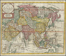
Rarity / States of the Map
The map was first issued by Danet in 1731 and later revised by Desnos, at which time he significantly revised the cartographic details. This Desnos edition of the map is quite rare on the market..
North Pacific chimeras: Yesso, De Gama, and Compagnie Land
The etymology of the idiom Yesso (Eso, Yeco, Jesso, Yedso) is most likely the Japanese Ezo-chi; a term used for the lands north of the island of Honshu. During the Edō period (1600-1886), it came to represent the ‘foreigners’ on the Kuril and Sakhalin islands. As European traders came into contact with the Japanese in the seventeenth century, the term was transferred onto European maps, where it was often associated with the island of Hokkaido. It varies on maps from a small island to a near-continent sized mass that stretches from Asia to Alaska.
The toponym held interest for Europeans because the island was supposedly tied to mythic riches. Father Francis Xavier (1506-1552), an early Jesuit missionary to Japan and China, related stories that immense silver mines were to be found on a secluded Japanese island; these stories were echoed in Spanish reports. The rumors became so tenacious and tantalizing that Abraham Ortelius included an island of silver north of Japan on his 1589 map of the Pacific.
Yesso is often tied to two other mythical North Pacific lands, Gamaland and Compagnies Land. Juan de Gama, the grandson of Vasco de Gama, was a Portuguese navigator who was accused of illegal trading with the Spanish in the East Indies. Gama fled and sailed from Macau to Japan in the later sixteenth century. He then struck out east, across the Pacific, and supposedly saw lands in the North Pacific. These lands were initially shown as small islands on Portuguese charts, but ballooned into a continent-sized landmass in later representations.
Several voyagers sought out these chimerical islands, including the Dutchmen Matthijs Hendrickszoon Quast in 1639 and Maarten Gerritszoon Vries in 1643. Compagnies Land, often shown along with Staten Land, were islands sighted by Vries on his 1643 voyage. He named the islands for the Dutch States General (Staten Land) and for the Dutch East India Company (VOC) (Compagnies, or Company’s Land). In reality, he had re-discovered two of the Kuril Islands. However, other mapmakers latched onto Compagnies Land in particular, enlarging and merging it with Yesso and/or Gamaland.
In the mid-eighteenth century, Vitus Bering, a Danish explorer in Russian employ, and later James Cook would both check the area and find nothing. La Perouse also sought the huge islands, but found only the Kurils, putting to rest the myth of the continent-sized dream lands.