


|
||

|

|
|

|
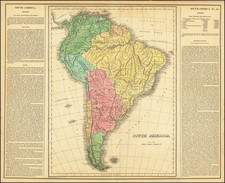
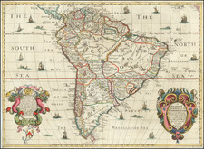
John Cary's 1811 dual-sheet cartographic depiction of South America is a significant testimony to the cartographic knowledge and curiosity of the period. Highlighting a broad range of geographical features, from urban settlements, river systems, and mountains, to islands and lakes, it captures the continent with commendable intricacy.
By the start of the 19th century, South America was a continent in flux, subjected to intense colonial interest and exploration. The cartographers of the time faced the challenge of mapping a vast, diverse, and often little-understood territory. Cary's map, with parts of the Amazon region labeled as "Unexplored Parts," is a clear reflection of these challenges and the state of geographic knowledge of South America in the early 19th century.
Cary's map, as well as being a practical tool, is a visual reflection of the curiosity and ambition of the age, mirroring the spirit of discovery and expansion that defined the period. Although the map reveals the still rudimentary understanding of certain areas, such as the Amazon, it also embodies the thirst for knowledge and the sense of possibility that marked the early 19th century.
The value of the map, therefore, lies not only in its presentation of the continent as understood in 1811 but also in its capacity to illuminate the aspirations and limitations of its time. It offers viewers a tangible link to a moment in history when much of the world was yet to be fully explored, making it a compelling addition to any collection of antique maps or historical artifacts.
John Cary (1755-1835) was a British cartographer and publisher best known for his clean engraving and distinct style which influenced the entire map industry. Born in Wiltshire, John was apprenticed to an engraver in London. He started his own business by 1782 and moved to several premises before settling at 86 St James’s Street in 1820.
Cary had several significant collaborations during his career. John Wallis and Cary diversified Cary’s business to include broader publishing projects. Brother William and John made globes together, while brother Francis participated in the company’s engraving work. Finally, geologist William Smith and Cary developed and sold geological maps, some of the first of their kind. The pair also produced a notable series of county maps starting in 1819. Cary’s atlases, of English counties and the world, were the standard texts of the early nineteenth century. He was appointed surveyor of roads to the General Post Office in 1794, which led to the New Itinerary, first published in 1798.
John trained his son, George, in engraving and George and his other son, John Jr., took over the business in 1821. It was then known as G. and J. Cary and continued in trade until 1850. The firm’s materials were then acquired by George Frederick Cruchley and then Gall and Inglis. By the time John died in 1835, Cary was the authoritative name in private map publishing and his business was a leader in the field throughout the first half of the nineteenth century.
![[ First State of the First Map of America ] Novae Insulae XVII Nova Tabula](https://storage.googleapis.com/raremaps/img/small/94609.jpg)