|
||

|

|
|

|
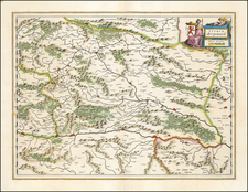
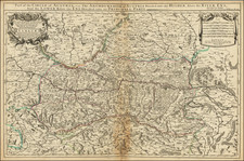
The Austrian landscape of the early 18th century was a fascinating mesh of political complexity, socio-economic transformation, and vibrant cultural life. This period, often referred to as the Baroque era, bore witness to the Habsburg Monarchy's dominance under the rule of iconic figures like Leopold I, Joseph I, Charles VI, and Maria Theresa. A fascinating illustration of this era is an antique map of Austria circa 1720, centering around the course of the Danube River, from Ips to Braunau.
This map, meticulously crafted with the level of detail one would expect from a master cartographer of the time, provides more than just geographical bearings. It serves as a snapshot of Austria's historical narrative, a time of progression and change. The Danube River, a prominent feature of the map, is more than just a body of water; it represents the pulse of Austria's commercial life. Braunau, located to the west of the Danube, and Ips, to the east, became important commercial centers due to their strategic location.
Smaller towns and cities like Salzburg, Rachstats, Rottenman, Loeben, Waiddhofen, Zwetl, Weitra, and Passau are carefully dotted along the river and the surrounding landscape. Each of these was unique, with their cultural identities and contributions to the region's commerce and trade. Salzburg, renowned for its rich cultural history and the birthplace of Mozart, was particularly noteworthy.
Agriculture was another crucial aspect of Austrian life in this era, the primary commodities being grains, potatoes, and dairy. The regions surrounding Zwetl and Weitra were particularly known for their agriculture, as indicated by the pastoral imagery on the map.
This map, while a representation of the Austrian region's geographical elements, also narrates the socio-political and economic climate of the period. The course of the Danube River and the cities it encompasses played a crucial role in the development and prosperity of Austria, creating a hub of trade and commerce, a melting pot of cultures, and a stronghold of political power.
Johann Baptist Homann (1663-1724) was a mapmaker who founded the famous Homann Heirs publishing company. He lived his entire life in Bavaria, particularly in Nuremberg. Initially, Johann trained to become a priest before converting to Protestantism and working as a notary.
In 1702, Johann founded a publishing house that specialized in engravings. The firm flourished, becoming the leading map publisher in Germany and an important entity in the European map market. In 1715, Johann was named Imperial Geographer to the Holy Roman Empire by Charles VI and made a member of the Prussian Academy of Sciences. Most importantly for his business, his reputation and contacts gained him imperial printing privileges which protected his publications and recommended him to customers. Johann is best known for this Grosser Atlas ueber die ganze Welt, or the Grand Atlas of the World, published in 1716.
After Johann died in 1724, the business passed to his son, Christoph (1703-1730). Upon Christoph’s early death, the company passed to subsequent heirs, with the name of the company changing to Homann Erben, or Homann Heirs. The firm continued in business until 1848.
![[ Holy Roman Empire ] A Newe Mape of Germany Newly Augmented by Iohn Speed Ano Dom: 1626](https://storage.googleapis.com/raremaps/img/small/68482.jpg)