


|
||

|

|
|

|
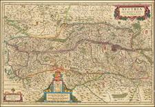
Crafted around 1720, the map of the Principatus and Archiepiscopatus of Salzburg provides an intricate snapshot of the region during this historical period.
The Salzach River, the lifeblood of the area, meanders through diverse towns and cities, each painstakingly marked. Lakes, mountains, and rivers ornament the landscape, their representations punctuated by bridges—indicators of the significant engineering feats of the time.
A notable feature of the map is its depiction of the booming salt mining industry, evidenced by distinct symbols marking salt mines, a testament to the industry's role in shaping the economic and cultural fabric of the region.
Salzburg, the residence of the Prince-Archbishop, holds a place of prominence. As the religious and political epicenter of the region, it's significantly highlighted. Meanwhile, settlements such as Friesach and Strasburg on the Gurk River, and Sankt Andre on the Lavant River, offer glimpses into the region's rural existence.
A captivating alpine scene comes to life within a decorative cartouche at the top left of the map. Activities such as hunting and smelting are illustrated, symbolizing the region's natural bounties. Two allegorical female figures accentuate the scene, underscoring the area's agricultural, hunting, and fishing richness.
The map's focal point is a grand vignette featuring Franz Anton von Harrach, the influential Prince-Archbishop of Salzburg from 1709 to 1727. Surrounded by allegorical figures representing the Holy Roman Empire, the tableau illustrates Harrach's prominence and far-reaching influence. Cherubs and heralds, poised with a trumpet, crown, and purple robes, suggest the anticipation of dressing Harrach in royal attire.
Below this depiction, a globe emphasizes Salzburg's central position, encircled by nine cherubs adorned in cardinal's hats and holding staffs. Following this, the scene titled "prospectus Montis Plain prope Salisb," or "view of the Plain mountain near Salzburg," demands attention. This intriguing title likely refers to Maria Plain, a pilgrimage church located on Plainberg mountain near Salzburg, with a portion of the church's outer structures shown. Its representation on the map indicates its religious significance during this era. The scene shows an allegorical female figure resting on a large cask, her gaze directed upward toward the cherubs. This might symbolize the relationship between the physical landscape, its bounty, and the strong spiritual influence of sites like Maria Plain in the region.
The map includes a remarkably comprehensive set of symbols, which include:
Erklärung der Zeichen - Explanation of the symbols
STÄTT - Cities
Märck - Markets
Hof-Marck - Court market
Schlößer - Castles
Dorffer - Villages
Gepfarrte Dorffer - Parished villages
Paß durchs Geburg - Pass through the mountains
Erz-Bifch Bifchofft - Archbishop Bishopric (seems like it's written in an old German script, correct modern German would be 'Erzbischof Bischoftum')
Univerfitat - University
Refident - Residence
Clofter Cong. Bened. Salisb - Monastery Congregation of the Benedictines of Salzburg (again, written in old German, correct modern German would be 'Kloster Cong. Bened. Salzburg')
Andere Clofter - Other monasteries
Marianische Wallf - Marian pilgrimage sites
Andere Wallfahrten - Other pilgrimage sites
Bergwerck. Gold. Silber. Kupfer. Eisen. Bley, Schwefel Stahl - Mines: Gold, Silver, Copper, Iron, Lead, Sulphur, Steel
Queksilber. Vitriol. Galmey, Schmelzwerck Hamerwerck. Salz - Mercury, Vitriol, Galmei, Smelting works, Hammer works, Salt
Pflegen - Care (this could potentially refer to administrative districts or care institutions, depending on context)
Land Gericht - Country court
Poft Abwechsl - Post exchange
Poft Weg - Post route
Landstraß - Country road
Pruggen - Bridges
Holzrechen - Wood rake (or potentially a mechanism for collecting logs in rivers)
Johann Baptist Homann (1663-1724) was a mapmaker who founded the famous Homann Heirs publishing company. He lived his entire life in Bavaria, particularly in Nuremberg. Initially, Johann trained to become a priest before converting to Protestantism and working as a notary.
In 1702, Johann founded a publishing house that specialized in engravings. The firm flourished, becoming the leading map publisher in Germany and an important entity in the European map market. In 1715, Johann was named Imperial Geographer to the Holy Roman Empire by Charles VI and made a member of the Prussian Academy of Sciences. Most importantly for his business, his reputation and contacts gained him imperial printing privileges which protected his publications and recommended him to customers. Johann is best known for this Grosser Atlas ueber die ganze Welt, or the Grand Atlas of the World, published in 1716.
After Johann died in 1724, the business passed to his son, Christoph (1703-1730). Upon Christoph’s early death, the company passed to subsequent heirs, with the name of the company changing to Homann Erben, or Homann Heirs. The firm continued in business until 1848.

![[ Railroad Map of Austro-Hungarian Empire ] Eisenbahnkarte von Oesterreich-Ungarn](https://storage.googleapis.com/raremaps/img/small/89257.jpg)