|
||

|

|
|

|
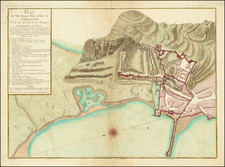
This is a detailed plan of the city and mountain of Gibraltar, corrected according to original English maps, was made by Louis Denis and published in Paris by Basset. The map features comprehensive labels and an accompanying legend. The design makes it a resource of great historic and geographic significance.
The Renvoi (French for 'reference') serves as a key or legend to the plan, labeling various important locations within the city and mountain of Gibraltar. These include bastions, gates (Portes), the old Moorish Castle (Vieux Château des Maures), and the Governor's House (Maison du Gouverneur). The locations are named in French with an alphabetical notation, and each notation corresponds to a location marked on the plan.
The note at the end, which references the numbers in the sea, refers to the depth of the water measured in fathoms (brasses d'eau), a common practice in maritime charts.
This geometric plan, therefore, serves as a comprehensive historical document, presenting an intricate snapshot of Gibraltar as understood in the period it was created. Its incorporation of English sources further adds to its significance, indicating a cross-cultural exchange of geographical knowledge.
In 1781, Gibraltar, located at the southern end of the Iberian Peninsula, was a pivotal point of geopolitical interest due to its strategic location at the entrance of the Mediterranean Sea. British possession of Gibraltar facilitated control over Mediterranean trade and naval movements, a fact that wasn't lost on Spain and its allies.
This year falls in the midst of what is known as the Great Siege of Gibraltar (1779-1783), which was an attempt by Spain and France to recapture Gibraltar from the British during the American War of Independence. During this period, Gibraltar was under consistent attack from Spanish and French forces on both sea and land.
While Spain hoped the War of American Independence would distract Britain and weaken its control over Gibraltar, the British forces in Gibraltar demonstrated remarkable resilience. The garrison, under the command of General George Eliott, managed to resist all attacks, employing a range of defensive measures including the innovative use of heated shot.
In 1781, the siege was in its later stages. Spain and France intensified their efforts, beginning a heavy bombardment known as the 'grand attack' in November of 1781. Despite these intensified efforts, Gibraltar successfully resisted the siege until its end in 1783.
This period in Gibraltar's history was marked by significant hardship but also impressive resilience and innovation. Its geographical and strategic importance was highlighted, and its defenses were tested and proved robust. This context significantly influences contemporary perceptions and historic discussions of Gibraltar.
Louis Denis (1725-1794) was a French geographer and cartographer best known for his incomplete road atlas of France, Le Conducteur français. Originally trained as an engraver, he partnered with Louis-Charles Desnos to create and edit maps. Later, Denis served as geography tutor to the children of the French royal family. His pupils included the Duc de Berry, the future Louis XVI.
![[ Gibraltar ] Plan du promontoire de la ville et du port de Gibraltar avec les ouvrages faits depuis le dernier siège et les lignes construites par ordre de sa Majesté très catholique, pour empescher la communication de Gibraltar avec l'Espagne : levé nouvellement sur les lieux par l'ingenieur de la place.](https://storage.googleapis.com/raremaps/img/small/98510.jpg)
![[ Gibraltar ] Plan Topo-Hydrographique de la Baye de Gibraltar](https://storage.googleapis.com/raremaps/img/small/74381.jpg)