|
||

|

|
|

|
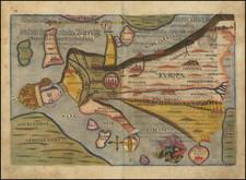
Vincenzo Maria Coronelli's two-sheet map of Europe, crafted in Venice around 1690, represents a notable artifact of late 17th-century cartography. The map spans from Greenland and Iceland to Russia, Ukraine, and the Mediterranean Sea, Black Sea and Caspian Sea, showcasing Coronelli's meticulous detail and engraving style.
One of the most striking features of the map is its depiction of Iceland, where Coronelli has intricately illustrated several volcanoes, including Mount Helca. The visual detailing doesn't only capture the geography of the region but also reflects the scientific knowledge of the time, including the active geological nature of Iceland.
The map also extends to include a section of the North American coast (likely Greenland), and intriguingly, the mythical island of Frisland is outlined tentatively. This fictitious island, first appearing on maps in the mid-14th century, is believed to have originated from a misunderstood account of the Zeno expedition, an alleged journey by Venetian brothers in the North Atlantic. Despite its mythical status, the inclusion of Frisland showcases the blend of known and speculative geography during this period.
Coronelli's treatment of the southern coastline of Greenland and its closeness to Iceland is noteworthy. Despite the inaccuracies - Greenland and Iceland are not as proximal in reality - this depiction reveals the limitations and uncertainties faced by cartographers of the time.
Nuova Zembla, an archipelago in the Arctic Ocean, receives a highly detailed portrayal. The careful rendering of this remote and icy region speaks to Coronelli's commitment to geographic inclusivity and detail, even in less explored areas.
The map is not without its artistic touches. The sea northwest of Norway hosts an unusual vignette, a dramatic scene of a sea monster being harpooned by men in open row boats. It is a fascinating glimpse into the maritime folklore of the time, blending the boundaries of myth and reality.
The map also includes two decorative cartouches and a scale of miles, features that were customary in the cartographic design of the era. The cartouches add an aesthetic appeal, balancing the scientific precision of the map with artistic elements.
Coronelli's map of Europe is a testament to the level of detail and geographical understanding of the late 17th century. The map showcases his remarkable engraving style, which, when combined with access to the most accurate French maps, led to some of the most precise depictions of the era. Coronelli's influence on cartography extended beyond his lifetime, and his map of Europe remains a significant piece of historical geography.
Vincenzo Maria Coronelli (1650-1718) was one of the most influential Italian mapmakers and was known especially for his globes and atlases. The son of a tailor, Vincenzo was apprenticed to a xylographer (a wood block engraver) at a young age. At fifteen he became a novice in a Franciscan monastery. At sixteen he published his first book, the first of 140 publications he would write in his lifetime. The order recognized his intellectual ability and saw him educated in Venice and Rome. He earned a doctorate in theology, but also studied astronomy. By the late 1670s, he was working on geography and was commissioned to create a set of globes for the Duke of Parma. These globes were five feet in diameter. The Parma globes led to Coronelli being named theologian to the Duke and receiving a bigger commission, this one from Louis XIV of France. Coronelli moved to Paris for two years to construct the King’s huge globes, which are 12.5 feet in diameter and weigh 2 tons.
The globes for the French King led to a craze for Coronelli’s work and he traveled Europe making globes for the ultra-elite. By 1705, he had returned to Venice. There, he founded the first geographical society, the Accademia Cosmografica degli Argonauti and was named Cosmographer of the Republic of Venice. He died in 1718.
![[Rare Complete Example with Game Pieces] Grand Circuit Des Capitales. Collection Concours Du Chocolat Menier](https://storage.googleapis.com/raremaps/img/small/70922rd.jpg)
![[ Holy Roman Empire ] Germania, Non ea tantum quae Rheno, Vistula, Danubio, mariqz Germanico Veteribus claudebatur; Sed tota illa continens quae hodie communiter Germanica lingua utitur . . .](https://storage.googleapis.com/raremaps/img/small/99236.jpg)