|
||

|

|
|

|
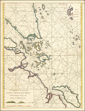
The chart titled Chart of the West Coast of Sumatra, From Bencoolen to Key Sers Bay is an exceptional illustration of the coastal cartography of Sumatra in the late 18th century. Published by Laurie & Whittle on 12th May 1794, this comprehensive work includes contributions from Captain Joseph Huddart and Mr. John Price, both distinguished figures in maritime navigation during this period. The chart encapsulates multiple perspectives of the coastal geography, featuring additions like the "Plan of Cawoor Bay," "Plan of Pulo Pisang," and "Plan of Little Fortune Island and Billimbing Bay."
The chart conveys the complexities of Sumatra's west coast from Bencoolen to Key Sers Bay with substantial detail. Captain Huddart, a prominent sea captain and hydrographer known for his improvements to nautical charts contributed most of the knowledge depicted here. His navigational expertise is evident in the detailed plans of Cawoor Bay, Pulo Pisang, and Little Fortune Island and Billimbing Bay, illustrating an intimate knowledge of these waterways.
Adding to the richness of the chart are the observations by Mr. John Price, the Chief Mate of the Kent in 1786. His notes offer precious firsthand accounts of the maritime conditions near Pring, where the ship Kent anchored to load pepper. His detailed description of the anchorage, noting the sudden change in depth and the quality of the seabed, offers an invaluable account of the coastal conditions and navigational challenges during that period.
The chart also includes a coastal profile showcasing the appearance of the land between Manna Point and Padang-Cochin. This feature, a common inclusion in nautical charts of the era, offers a visual guide to sailors about the land's appearance from sea level, further enhancing the chart's practical value.
Overall, this chart of the West Coast of Sumatra embodies the depth of maritime knowledge in the late 18th century. It stands as a testament to the significant collaborative efforts of individuals like Captain Huddart and Mr. John Price, whose firsthand experiences and expertise significantly enhanced the understanding and navigation of these challenging coastal waters.
Robert Laurie (ca. 1755-1836) and James Whittle (1757-1818) formed their Fleet Street, London-based firm upon the 1794 death of their employer Robert Sayer, himself one of the dominant print and mapmakers of the last half of the 18th century.
Laurie & Whittle started managing Sayer's business as early as 1787. They took over all managerial duties when Sayer's health flagged in 1792, and they changed the imprint in 1794 upon his death. Sayer left the two a 21-year lease on the shop (at £100 a year) and on Sayer's Bolt Court premises, as well as an option to acquire stock and equipment at a preferential price of £5,000 payable over three years.
Robert Laurie retired from the firm in 1812, and his role was assumed by his son, Richard Holmes Laurie (1777-1858). The younger Laurie worked with James Whittle until the latter died in 1818. After R. H. Laurie died in 1858, Alexander George Findlay, FRGS (1812-1875) purchased the firm from his daughters. The firm continues today under another name, specializing in yachting charts.
Laurie & Whittle were prolific print and map publishers, and throughout their careers, they produced numerous very important and rare works. They carried on Robert Sayer's atlas business and were responsible for editions of The Complete East-India Pilot and The American Atlas.