|
||

|

|
|

|
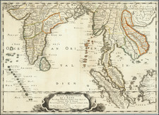
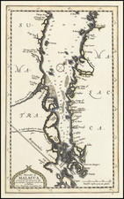
A New Chart of the Northern Part of the Straits of Malacca, From Acheen to Malacca is a historically significant navigational chart capturing the northern region of the Malacca Strait, nestled between Sumatra and the Malay Peninsula. This chart was published in Laurie & Whittle’s rare East India Pilot, a crucial navigation tool used by officers of the Royal Navy and East Indiamen.
The chart is an adaptation and enhancement of d’Apres Mannevillette’s Carte Plate de la partie Septentrionale du Detroit de Malac, depuis de la rade d’Achem jusqu’a Malac (1775). The original was published in English by Sayer and Bennett in 1778, but this Laurie & Whittle edition brings more detail and updated features, including a coastal profile and an inset in the upper right, which displays a "Plan of Poolo Pinang, now Prince of Wales’s Island."
A unique aspect of this map is its careful inclusion of details about the Eastern Coast of Sumatra. Despite acknowledging that the area is "imperfectly known" due to limited European contact, the chart still includes essential soundings along the coastal track commonly used by ships.
Produced by the partnership of Robert Laurie and James Whittle, who took over Robert Sayer's business in 1794, this chart and the 'East India Pilot' series it belongs to were important navigational resources during the height of British seafaring trade and exploration in the East Indies. It reflects the significant efforts of Laurie & Whittle to provide accurate, practical maps for maritime navigation, particularly in the highly trafficked, strategically critical waters of the Malacca Strait.
The partnership of Laurie and Whittle, later taken over by Richard Holmes Laurie, marked a critical phase in the history of British cartography, leading to the creation of renowned chartmakers and publishers Imray, Laurie, Norie, and Wilson. The "New Chart of the Northern Part of the Straits of Malacca, From Acheen to Malacca" stands testament to their significant contribution to maritime navigation and cartography.
Robert Laurie (ca. 1755-1836) and James Whittle (1757-1818) formed their Fleet Street, London-based firm upon the 1794 death of their employer Robert Sayer, himself one of the dominant print and mapmakers of the last half of the 18th century.
Laurie & Whittle started managing Sayer's business as early as 1787. They took over all managerial duties when Sayer's health flagged in 1792, and they changed the imprint in 1794 upon his death. Sayer left the two a 21-year lease on the shop (at £100 a year) and on Sayer's Bolt Court premises, as well as an option to acquire stock and equipment at a preferential price of £5,000 payable over three years.
Robert Laurie retired from the firm in 1812, and his role was assumed by his son, Richard Holmes Laurie (1777-1858). The younger Laurie worked with James Whittle until the latter died in 1818. After R. H. Laurie died in 1858, Alexander George Findlay, FRGS (1812-1875) purchased the firm from his daughters. The firm continues today under another name, specializing in yachting charts.
Laurie & Whittle were prolific print and map publishers, and throughout their careers, they produced numerous very important and rare works. They carried on Robert Sayer's atlas business and were responsible for editions of The Complete East-India Pilot and The American Atlas.
![[Moluccas] Caart van het Eyland Manipa [on sheet with] Caart van het Eyland Noessa-Laoet [and] Caart van het Eyland Honimoa [and] Caart van het Eyland Oma](https://storage.googleapis.com/raremaps/img/small/74805.jpg)