|
||

|

|
|

|
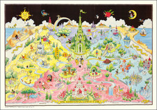
Fine example of Elizabeth Shurtleff's rare pictorial map of the Shoals Isles or Smith Isles, originally published in 1927 by the Walker Lith. Co of Boston.
Elizabeth Shurtleff's pictorial map of the Shoals Isles, or Smith Isles, is a remarkable visual treat that invites viewers on a journey through time and space. Published in 1927 by Walker Lith. & Pub. Co. of Boston, this vintage map delivers a historical perspective of the Isles of Shoals, an archipelago located about six miles off the coasts of Maine and New Hampshire, including the islands of Appledore, Star, Cedar, Smuttynose, Malaga, Lunging or Londoners, and Seavey or Whilte Island.
In Shurtleff's style, the map is far from being merely a geographical tool; instead, it is a narrative-rich artwork that tells the story of the Isles of Shoals. Historical events, folklore, and notable landmarks are cleverly represented through detailed illustrations and accompanying textual descriptions. Fishing and sailing vessels dot the ocean, signifying the islands' rich maritime history.
One of the notable features is the intricate representation of buildings and structures. Star Island's Oceanic Hotel, Appledore's Celia Thaxter's cottage, and the old Gosport Church are few among the landmarks beautifully rendered, allowing a glimpse into the architectural aesthetics of the era.
Includes an image of John Smith and several views of lighthouses and Celia Thaxtons' House.
Rarity
The map is apparently quite rare. We note copies in the Osher Library and John Carter Brown.
![[Oranje Freistaat, Transvaal and Kap Kolonie Game Board]](https://storage.googleapis.com/raremaps/img/small/80146.jpg)