


|
||

|

|
|

|
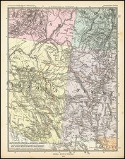
This 1872 map of the Military Department of the Platte, prepared under the direction of Captain William A. Jones, offers a detailed picture of the Platte River watershed and the Plains during the period of Indian Campaigns in the United States. Published in Omaha, Nebraska, for the Secretary of War, this exceptional piece of military cartography highlights the infrastructure and geographical features of a crucial region during a turbulent time in Westward Expansion.
Captain William A. Jones, serving as the Chief Engineer of the Department of the Platte, was engaged in the exploration of the headwaters of the Platte River during this period. His goal was to identify a feasible route for a wagon road from the Union Pacific rail line in Wyoming to Fort Ellis in Montana Territory. This mapping expedition resulted in significant manuscript maps that provided crucial topographical information, aiding military campaigns and supporting the expansion of infrastructure in the region.
What stands out in Jones' map is the detailed representation of key features of the Platte River watershed. Military posts, Indian agencies, roads, railroads, rivers, and Indian reservations are all clearly marked. It underlines the major trails and roads connecting various military posts, along with a comprehensive illustration of the region's hydrography. Such focused depiction underscores the strategic importance of this area during the Indian Campaigns.
This map is exceedingly rare in the antiquarian market. We have handled it once before.

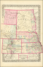
![[ Western United States -- Massive Idaho Territory ]](https://storage.googleapis.com/raremaps/img/small/99057.jpg)