


|
||

|

|
|

|
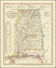
Fantastic 19th-century geological map of Alabama, with an accompanying chart describing the region's strata.
This map provides a broad overview of the geological coverage of Alabama. It encompasses a wide range of formations, ranging in age from the Cambrian to Quaternary. "Crystalline" Strata are also shown. The map's coverage is extensive and would have provided crucial information to geologists at the start of the 20th century.
To understand the historical context of this chart, it is crucial to recognize its connection to the Geological Reports of Alabama. These reports, published in the late 19th century, contain in-depth studies and analyses conducted by experts in the field. They explore various aspects of Alabama's geology, such as coal mining, fresh-water shells, crystal formations, and the geological characteristics of specific regions. The Geological Survey of Alabama aimed to shed light on the state's geological resources, offering valuable information for scientific research, mining endeavors, and land development. Together, these studies were able to provide a holistic description of the region's geology, synthesized onto this map.
The map was published by the Geological Survey of Alabama, under the guidance of Eugene Allen Smith, the State Geologist, and Henry McCalley, his chief assistant. The map was printed in New York by Jules Bien & Co.
![(18th-Century Southern Borderlands) [Collection of manuscript letters to Secretary of War James McHenry from confidential U.S. agent John McKee, relating to southern borderlands, Native Americans and Panton, Leslie & Co.; a letter from John McKee written from Mobile, Alabama, to William Blount of Blount's Conspiracy fame; a letter from William Panton concerning John McKee; and letters from Felix D. St. Hilaire, concerning General Victor Collot]](https://storage.googleapis.com/raremaps/img/small/90005.jpg)
![(The First Letter From British Florida) [September 5, 1763, Autograph Letter, Signed, from Robert Campbell to John Campbell, 4th Earl of Loudoun, describing the British taking possession of Florida and the state of the settlement of Pensacola]](https://storage.googleapis.com/raremaps/img/small/86620.jpg)

![[Florida to New Orleans] The North Coast of the Gulf of Mexico from St. Marks to Galveston . . . 1842](https://storage.googleapis.com/raremaps/img/small/83469.jpg)