


|
||

|

|
|

|
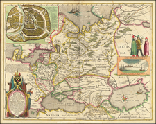
This large 1812 twelve-sheet folding map of Russia, laid down by Ivan Danielov ("Jwan Danielow) and published by Tranquillo Mollo in Vienna, offers a detailed depiction of the region stretching from the Black Sea to the Arctic, and from parts of the Caspian and Aral seas to a bit east of the Ural Mountains, covering the Ob River watershed.
As Europe transitioned into the 19th century, geopolitical realities shifted dramatically. This period witnessed the rise of Napoleon Bonaparte, whose territorial ambitions rippled across Europe, culminating in the pivotal invasion of Russia in 1812. Amidst this tumult, Vienna—home to influential circles of diplomacy and the arts—played host to a spectrum of intrigues. This map might best be understood against this backdrop. Its creation aligns with the tactical necessity of understanding Russia’s complex terrain, a knowledge that would have been of interest to various entities.
Ivan Danielov's map stands as a testament to the detailed cartographical knowledge of the time. He incorporated the latest astronomical location determinations, the "grand atlas," and other maps from the Russian imperial geographical depot. The map, divided into governorates, shows borders corrected according to the latest peace treaties. It also provides essential details, including post and other main roads, with notes on place distances—an essential tool for understanding the scale and logistical challenges of traversing this vast expanse.
The use of both German and French language in the map points to the linguistic and cultural dynamics in Europe at that time. French was the international language of diplomacy, while German held significant sway in Central Europe, particularly within the Habsburg Empire. The choice to publish the map in Vienna, a crossroad of cultures, might have been influenced by the city's strategic location and its role as a hub for information dissemination, likely aiming to cater to a wide audience interested in the rapidly transforming geopolitical landscape.
This detailed cartographic representation of Russia in the early 19th century offers insight into the concerns and complexities of a transformative period in European history. It not only served practical purposes for navigation and understanding territory but also reflected the geopolitical ambitions and anxieties of an era defined by the Napoleonic wars. As a piece of historical scholarship, it allows us to visualize and better comprehend the considerable geographic challenges that such territorial ambitions entailed.
![[Caspian Sea / Kamtchatka] Geographica Nova ex Oriente gratiosissima, duabus tabulis specialissimis contenta, quaram una Mare Caspium. . .](https://storage.googleapis.com/raremaps/img/small/89998.jpg)